Asia Jabeen1* and Mazhar Munir2
1Lahore College for Women University Lahore, Pakistan
2Mazhar Munir Designz, Lahore, Pakistan
* Corresponding Author: [email protected]
Urban transformations play a vital role in developing or ruining the historic urban landscape of heritage sites. Indeed, there is a close relationship between urban morphology and cultural and socioeconomic activities conducted in the urban spaces of historic cities. The current urban interventions and intrusions have fashioned new developments in and outside the historic core of Lahore. Chowk Wazir Khan, situated in the Walled City of Lahore, contains intricate Mughal architectural elements and remains a versatile public space that serves as a center of cultural and economic activities. This study is focused on the priorities of urban transformations during the revitalization, regeneration, and reconstruction projects implemented in view of preserving the socioeconomic sustainability of the aforementioned heritage site. The interventions like conscious transportation, landuse, street scape etc have a great impact on the built environment, also affect the continuance of the traditional roles within historic environment. The main aim is to explore these socioeconomic variables within the historic setting and their impacts on the heritage site. The study also aims to draw the indicators which generate pressures on the historic city. The current research would help to discover the complex economic and technological processes enacting urban change in order to balance social activities, support the future of the historic center, and contribute towards social sustainability. To conclude, urban transformations in historic cities such as the Walled City of Lahore must be planned and centered to its historic urban fabric. Furthermore, public urban spaces should be intended and organized keeping in view the economic needs of the residents.
Keywords: chowk Wazir Khan, cultural activities, historic urban landscape, public open spaces, socioeconomic sustainability, urban transformation
The historic character and landscape of historic cities is based on their context, urban interventions, and premeditated sites. These elements play a key role to define the relationship between urban morphology and traditional characteristics of the built heritage. The urban fabric of the historic city of Lahore includes thirteen city gates in the city wall and main streets known as guzars. These streets link the city gates and secondary streets known as gali/koochas and public open spaces called chowks or squares (which comprise the junctions of the main spines or guzars). The Walled City of Lahore is divided into nine districts and each district is further divided into mohallas and koochas through galies and cul-de-sacs.
The physical fabric of the Walled City of Lahore includes significant monuments and cultural hubs. The current interventions to rehabilitate the old city have influenced socioeconomic activities as well as the traditional character of open spaces within the heritage site. The historic city of Lahore was greatly influenced by rulers who occupied the subcontinent and left their values and norms in the form of tangible and intangible heritage The Mughal era in the Indian subcontinent lasted from1526 untill 1857. This period was magnificent in terms of city growth which reached its peak when Emperor Akbar acknowledged Lahore as the headquarter of the Mughal empire. The city upheld this status from 1584 to 1598. After the Mughals, Sikh rulers occupied the city and ruled from 1764 to 1846. The British conquered the city in 1846 and their rule continued untill the partition of India in 1947. The region experienced significant contributions from both the Mughal and British rulers, with the Sikh rule as an intermediary period (Goulding, 1924). Hence, to study the current social, economic, traditional, and historic character of the historic core of Lahore (Gulzar, 2017),three dominant historical periods namely the Mughal, Sikh, and the British need to be explored. The physical intrusions made after independence need to be assessed also while envisioning the future of the city (Sajjad et al., 2020).
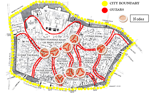
During the rule of Emperor Akbar, Lahore was not confined inside the city walls but extended towards the adjacent areas, such as Chah Miran, Kot Khawaja Saeed, Singh Pura, Mughal Pura, and many others. Emperor Akbar divided Lahore into thirty-six districts for administrative purposes. Nine of these districts are inside the walls of the old city. The districts inside the Walled City were separated by the main spines or guzars and the intersection of these guzars were termed as chowks. These chowks were the hub of commercial and cultural activities (Yamane et al., 1998).
Figure 1
Administrative Areas, Guzars, City Boundary, and Nodes
Note. Source: PEPAC Monographs (modified by author)
Today, the most important and significant element of the city is Masjid Wazir Khan and the forecourt of the mosque is named as Chowk Wazir Khan (after the name of the mosque). This chowk is located on the way from Delhi gate to Texali gate. It is characterized with a religious environment and serves as a hub of cultural and religious activities. The main areas in the east and north of the principle mosque include hujras for devotees, shops of book binders, illustrators, and calligraphers. There is a bethak system used for small social gatherings. Food stalls and temporary shops for various products are also used to conduct commercial activities. Melas on religious ceremonials and qawwalis at night are the epitome of religious and cultural activities (Campos, 2015).
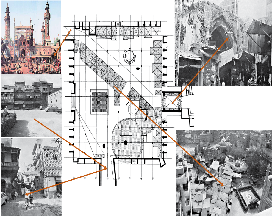
Due to recent interventions, the social and historic character of Chowk Wazir Khan changed. Chaos was created by the residents and shopkeepers of adjoining areas, sprouting an awful situation. The lack of administrative control to safeguard the heritage site was the major cause of this deterioration. The crossway linking Chitta gate to Chowk Kotwali was a persistent issue for the shopowners of the southern side. The chowk was impinged by semi-permanent edifices such as the tomb of Hazrat Syed Souf and the well of Dina Nath. The western façade of the mosque has been abandoned 2.5 meters deep in the ground due to the leftovers, thrown by the nearby residents.. The courtyard was apprehended by physical erections, static and dynamic shop fronts, debris, an electric transformer, and squatted shops on the diagonal path from the Chitta gate to Chowk Purani Kotwali (Agha Khan Cultural Services Pakistan [AKCSP], 2012).
Concerning the crumbling state of Masjid Wazir Khan and its square, the Walled City Lahore Authority took the initiative to rehabilitate the heritage site. Chowk Wazir Khan was revived on a priority basis due to its historic and architectural worth, as it is one of those squares which remain enclosed by a religious setting and serve as the forecourt of the principle mosque. The key objective of the project was to revive the historic, social, economic, and cultural roles of the site (Khan, 2021).
This research would help to plan the urban regeneration of open spaces enclosed within a historic environment. It would also help to analyze the pressures exerted due to unplanned urbanization and increased motorization, generating turmoil. Furthermore, this study would also help to design a plan for transportation in historic cities which were planned initially as pedestrian urban areas, segregating pedestrian and vehicular movement to introduce modern facilities in collaboration with traditional activities.
The current case study is placed in the historic core of Lahore, also known as the Walled City of Lahore. It is a hub for commercial as well as residential activities and contains various typologies of structures. The Walled City of Lahore has a mechanism of guzars (main spines), galies (streets), mohallas, and kuchas. Its urban hierarchy and morphology have been grimly affected by contemporary interventions. Modern facilities in this age of urbanization have transformed the socioeconomic pattern of life in all parts of the city. It is very important to review all the details available regarding the historic environment of the Walled City of Lahore (Rana & Bhatti, 2018).
The historic city of Lahore was a focal point of the trade route between Kabul, Delhi, and Kashmir. Chowk Wazir Khan, a historic urban square, managed and operated by the Walled City Lahore Authority. The Mughals upgraded the status of the city as a center of government. Sikhs introduced a blend of Mughal and indigenous architecture and introduced a new skyline to the architecture of lahore. British annexation introduced a different typology of buildings in the form of educational and public office buildings. They established a new colonial style city in the southwestern part of the Walled City and introduced new styles of architecture, while acknowledging the traditional elements of local architecture. The British introduced a range of residences and provided the local population with a chance to migrate towards the newly developed colonial style areas. The out-migration of local residents caused a decline in the standards of city life. A lot of pressures, such as increasing poverty, out-migration, and increase in vehicular movement inside the city walls have destroyed the historic character of the city (Ali, 1990).
The Walled City of Lahore was constructed with defensive walls for protection against enemies and invaders. During the Mughal period, the city was linked with the rest of India and expanded towards the nearby suburbs. It occupied two types of areas, one were located inside the city walls and the other comprised their surroundings. For administrative purposes, districts were established and the Walled City was divided into nine districts. The hierarchy of the city started from the city wall, continued through the city gates, and ended in cul-de-sacs, the innermost area of each district. City gates were linked through the main spines known as guzars. These guzars linked various districts to each other (Abid at el., 2017). The city was sub-divided into the following sections:
Figure 2
Kuchas / Mohallas, Galies, Chowks / Urban Squares
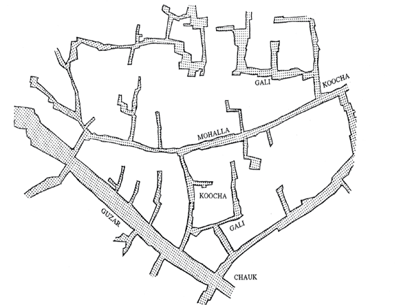
Note. Source: The Walled City of Lahore by SDWCL
Keeping in view the core objectives of the current research, desk-based methodology was adopted for data collection from the concerned departments, such as the Walled City Lahore Authority and Agha Khan Cultural Services of Pakistan, regarding the conservation of Chowk Wazir Khan. Afterwards, the site was visited to record its existing conditions and functions. A visual survey regarding the historic, cultural, and socioeconomic character of the area was conducted. The current function of the area was captured through digital images and compared with the past conditions on the basis of the collected data. . The revitalization of urban spaces within the Walled City was assessed by considering the restoration of its historic character and the revival of traditional activities, all within the context of preserving the monument's significance.The analysis was aimed to address the issues pertaining to the historic urban square, such as physical encroachments and visual barriers due to unplanned commercial activities. In the evaluation of the conservation plan, the examination of the current daily activities in the area aims to establish meaningful bridge with the past. By understanding and acknowledging the historical context, the plan seeks to ensure that the regeneration process effectively bridges the activities of today with their historical roots. This approach facilitates a sense of continuity and cultural heritage, creating a link between the present and the past. The exisitng policy to resolve the above mentioned issues was studied deeply in order to develop a platform for the conservation of urban open spaces in the historic city.
Chowk Wazir Khan is also known as "Jilaokhana" and it is a very significant part of the Wazir Khan Complex. It connects Delhi gate with Texali gate through Chitta gate and Chowk Purani Kotwali, linking them with Azam cloth market and Pakistan cloth market (Andrews, 1887). The chowk is in front of the eastern facade of the mosque and enclosed by buildings on three sides. The courtyard is 53 meters in the north-south direction and 47 meters in the eastwest direction. It has with five entrances, four in the middle of each side facade and fifth in the north-western corner, linking Chitta gate with Chowk Purani Kotwali. Masjid Wazir Khan is almost at the center of the Walled City of Lahore and can be approached through Delhi gate. After passing through Delhi gate, there comes a remarkable structure of old Lahore known as "Shahi Hammam". Walking towards the Chitta gate, there ware tangles of shops, junk of narrow curving streets, food stalls, and residences with jharokas and interwoven rooftops. The mosque was constructed in 1634 by Hakim Ilmudin during the reign of Emperor Shah Jahan. It is regarded as a masterpiece due to its intricate fresco and mosaic work (Agha Khan Cultural Services Pakistan [AKCSP], 2012).
Figure 3
Location of Chowk Wazir Khan
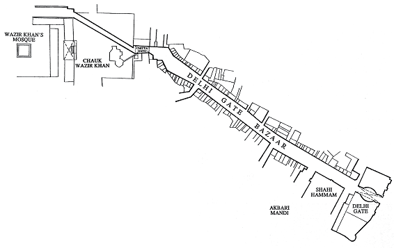
Note. Source: Walled City of Lahore (SDWCLP)
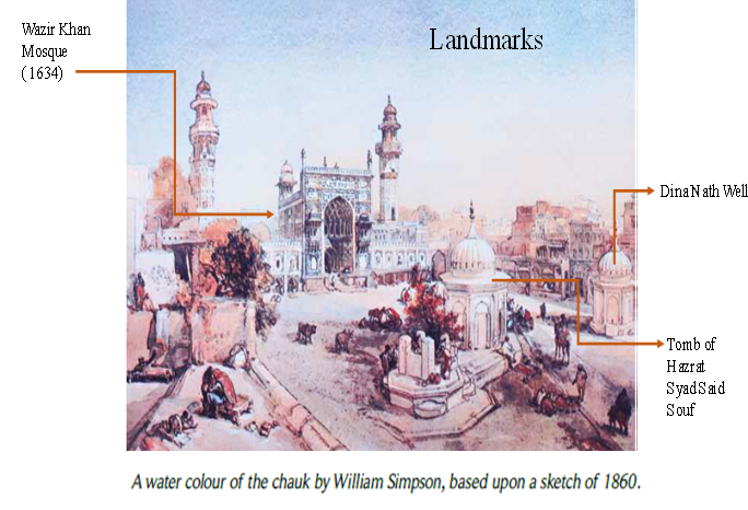
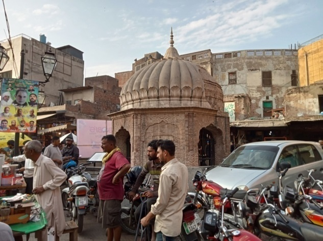
Another important feature of the mosque courtyard is the presence of hujras and shops on the northern and eastern sides. They comprise the financial resources available to meet the mosque expenditures. The shrine of Hazrat Syed Said Souf is located on the south-eastern corner and the well of Dina Nath is situated opposite to the shrine in the north-eastern corner. The well of Dina Nath is named after Dina Nath who was a finance minister appointed by the Maharaja Ranjit Singh.
The most significant landmarks of the Chowk Wazir Khan are the tombs of Syed Said Souf and Dina Nath Well.
Figure 4
Water Colour of the Chauk by William Simpson
Moving towards Chitta gate from Delhi gate, one can experience a disordered plethora of commercial activities in the form of vendors, static shop fronts, and physical intrusions as the outcome of recent interventions to provide modern facilities. After entering into the mosque courtyard through Chitta gate, the shrine of Hazrat Syed Said Souf is located on the left side of the eastern entrance. The grave of the saint is circumscribed in an octagonal structure which is ornamented with terracotta fretwork rectangles. There is a merlin pattern on the parapet walls and a finial of metal on the dome. The inner side of the entombment chamber and its surrounding area is decorated with complex mirror work and ornated with a chandelier (Khan, 2015).
Hazrat Syed Said Souf (1284) was a contemporary of the saint Hazrat Gazruni. He was buried in the basement located in the courtyard of the mosque. The sufi saint landed in Lahore during the period of Feroze Shah Tughlaq and was martyred in another encounter. Orignally, the site of the shrine was part of Mohalla Rara and Haveli Nadir Khan was also a part of this site. Shaikh Ilmudin, the Governor of Lahore also entitled as Nawab Wazir Khan, purchased land for the first principle mosque before the construction Of the Badshahi Masjid (Agha Khan Development Network [AKDN], 2012).
During the British Raj, Deputy Commissioner Major Macgregor took the decision to remove the buildings adjacent to the mosque to develop an open public space for religious and communal activities. The tomb of Hazrat Syed Said Souf was also situated in the vicinity of the mosque and was popular among the local residents, even during the Sikh period. Therefore, the contractor Mian Muhammad Sultan reconstructed the tomb with a marble plaque stating Mazar of Hazrat Syed Said Souf, built by Sheikh Sultan Contactor Sarkar Faiz Asar company angrez behadur da iqbal ahu (May their dignity last forever), in the year 1852, corresponding to 1908 Samvat and 1268 (Khan, 2015). Now there is a mosque with the tomb where prayers are held five times a day.
Dina Nath's well is located on the right side of the eastern side of Chowk Wazir Khan towards Chitta gate. Maharaja Ranjit Singh asked Diwan Dina Nath from Delhi to visit Lahore in 1815 in order to work in the military as the Head of Finance Department. Dina Nath belonged to a pandit family. He was appointed in the military as a mutsaddi or writer. He constructed a haveli having a well with walls and it was the only well with walls at that time. He died near Kot Khawaja Saeed in 1857. The surrounding area of the well was occupied illegally, generating squatted shops, static shop fronts, portable inclusions, parking purposes, and infrastructures, leaving no space to breath. All these activities destroyed the social and historic character of the space. During rehabilitation, all physical encroachments were removed to rejuvenate the urban space (Zahid & Misirlisoy, 2021).
The historic character of Chowk Wazir Khan was weakened by urban interventions and encroachments near the mosque, the tomb of Syed Said Souf, the well of Dina Nath, and in the area around the mosque. Due to the accumulated garbage, the level of the court in front of the mosque was raised and the hujras on the mosque's eastern facade were buried underneath. The chowk lost its original character and the traditional activities conducted in its vicinity became a thing of the past. The courtyard began to be utilized by shopkeepers of squatted businesses as a place to set up shops, a place for beggars to sit, and a corner was filled with transformers for the neighborhood's electricity supply. The path from Chitta gate to the north-western corner remained a critical issue for the shopkeepers of the southern side. The pedestrian area was transformed into a passage for vehicular movement, creating disarray. No segregation between pedestrian and vehicular movement could be seen in the chowk.
Figure 5
Plan of the Square Showing Encroachments

Note. Source: AKCSP ( modified by author )
Due to the encroachments of improvised commercial outlets, restrained by corrugated steel, the Shahi Guzargah lost the use of the Chowk Wazir Khan, which was run through with these retail shacks, and crowded by local citizens who seized the open space, employing it as a market. Since ages, the mosque and the chowk could not escape from the shackles of these encroachments and redundant structures.
The space of the chowk was occupied by the residents for numerous purposes, such as vehicular parking, to rest, and for the storage of luggage.
Pakistan Environmental Planning and Architectural Consultants (PEPAC) implemented its conservation plan in three stages. The first stage was aimed to remove the outer pressure through re-channelization. The second stage was aimed to protect the urban fabric of the city, and the third stage was related with the conservation and restoration of the urban areas of high historic value.
Walled City Lahore Authority and Agha Khan Cultural Services of Pakistan collaborated on a plan to renovate, revive, and regenerate Chowk Wazir Khan in light of its historic value and run-down state. United States Ambassadors Fund for Cultural Preservation (AFCP) contributed $1.2 million to the project's co-funding. The undertaking began in 2015 and was finished in 2017. The square surrounded by saturated urban context was selected for adaptive re-use. The square serves as a breathing space and provides a spatial experience embedded within the rich cultural backdrop in the historic inner city (AKCSP, 2012).
The restoration project included returning the chowk to its original form by digging 2.5 metres in order to separate the existing street level and the original ground level of the courtyard of the chowk. A retaining wall was built to avoid future encroachments and to ensure a protective bulwark for the hujras. As part of the project, Dina Nath's well, located in the northeast section of the square, was also conserved, while six metres of excavation in and around the well revealed historic construction from the Mughal and Sikh eras.
Counsel General Fidkew said that Chowk Wazir Khan was returned to its original shape and would serve as a community space where people can meet before and after prayers, arrange religious lessons, or examine handmade traditional goods sold in the hujras. He said that the restoration of the chowk would attract visitors to take a more intimate look into the historic city.
In April 2012, the Walled City Lahore Authority got Shahi Hammam and Chowk Wazir Khan cleared of encroachments. Meanwhile, the same authority with the help of Agha Khan Trust for Culture planned to protect the open space outside the mosque, so that the beauty of the mosque is not bruised any further. Besides other consolidation and repair works of the mosque, it was also decided to repair the shops and hujras and restore the original floor levels of the Shah Jahan era in front of the main entrance of the mosque. All this work was completed in the recent conservation effort (AKCSP, 2012).
Figure 6
Spatial Analysis of ChowkWazir Khan
The rehabilitation of the chowk and its refurbishment to its original status presents both the locals and tourists with an open vista where they can stay and enjoy the splendour and glory of the religious monuments. The chowk has resumed its historic role as an urban space for social interaction, where people can meet before and after prayers, perform religious poetry, and use handmade religious products sold in the eastern facade's fixed chambers (hujras). The conservation indicates a milestone in the resurgence of the Shahi Guzargah (Royal Trail) in the wider context of the Walled City, as a focal point in the itinerary of tourists and locals keen to get a more intimate feel of the historic city.
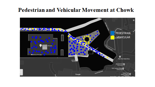
Figure 7
Pedestrian and Vehicular Movement around Masjid Wazir Khan and in Chowk Wazir Khan
This area has a lot of potential of becoming a Tourist as there are many social activities in this area that will make it a lively point of the Royal Trail.
Figure 8
Day v/s Night Activities at Chauk Wazir Khan
Chowk Wazir Khan not only serves as the forecourt of Masjid Wazir Khan, which was the grand mosque of the Walled City before the construction of Badshahi Masjid. The route from Lahore Fort to Masjid Wazir Khan is significant as Emperor and his courtiers used to travel from the fort to the mosque to say prayers via Masti gate through Chowk Kotwali. The people arriving from Delhi came to the mosque through Chitta gate and people arriving from Kabul came to the mosque through Masti gate and Delhi gate. The area surrounding the mosque was a hub of the havelies of Muslim nawabs and Sikh administrators. The main spines were commercial hubs providing eating and clothing facilities to the visitors, while upgrading the financial status of the residents. With the passage of time, there was a remarkable change in the social patterns of the local residents after the British annexation of Lahore. There was a shift from the Walled City to the colonial city, creating a potential for commercial activities. Vacant properties were occupied by the vendors, shopkeepers, and whole sale merchants. The changing socioeconomic scenario destroyed the historic character of the area. Chowk Wazir Khan became the center of commercial activities for shopkeepers and residents living in the close vicinity of the courtyard. The activities transformed from cultural and communal to commercial and vehicular for portable venders, squatted shopkeepers, parking place, debris, sitting space for beggars and even for provision of infrastructure by the local authorities. The eastern wall of the mosque was buried in the debris and level of the courtyard was raised up to 2.5 meters. The area was in dilapidated condition and needed attention. Walled City Lahore Authority took the initiative to regenerate the urban space as a pilot project to be implemented on the rest of the urban spaces of the Walled City, Lahore. Surveys were conducted and issues were documented with the help of digital technologies. A plan was proposed to revive the historic character of the urban space fulfilling the contemporary needs of the neighborhoods.. Squatted shops were a critical factor to deal with. Extraction to expose the eastern facade was another important part of the redevelopment plan. With all these, encroachments in the form of static shop fronts and semi-permanent shops adjacent to the walls of the mosque, tomb of the saint, and the well of Dina Nath damaged the traditional function of the courtyard. The restoration project was co-funded by the United States Ambassadors Fund for Cultural Preservation ( AFCP) with an amount of $ 1.2 Million. A house in front of the northern wall of the square manually documented by the Pakistan Environmental Planning and Architectural Consultants Limited (PEPAC) with the help of Building Information Modeling tool to maintain the accuracy. The manual data was digitized by conservation experts and the house was restored as a part of the historic environment (AKCSP, 2012). The project was completed Yet, there is a need to develop awareness among the people to change their attitudes towards the protection of heritage sites.
Figure 9
Chowk Wazir Khan after Regeneration

Note. Source: AKCSP
The project was completed with the aim of the rehabilitation of the historic urban square. In the historic city of Lahore, the forecourt of Masjid Wazir Khan is the only square with a religious environment. However, commercial activities around the square influenced the socioeconomic pattern of the whole area. Residential places were converted into markets, creating vehicular pressure. In this project, it was not possible to retrieve the chowk's original status, however, an effort was made to plan commercial activities with respect to the religious environment. The urban square was restored for tourists. The increasing tourist activities would help to support the residents economic status and change their social patterns . It would also help to create awareness among the residents about the importance of the heritage assets which they have. Hence, this project was intended bring socioeconomic sustainability with a sense of ownership.
The original function of the chowk was revived through the re-organization of pedestrian and vehicular activities from Chitta gate to the northwestern corner of the courtyard. The facades of Masjid Wazir Khan were refurbished. A trial was conducted to recover the facades of the buildings facing the chowk. However, shops squatting along the tomb of Hazrat Syed Said Souf and Dina Nath's Well still need to be removed. Commercial activities in the surroundings should be shifted to an appropriate space.
Historic urban squares in the Walled City are center of communal and cultural activities. These squares are breathing spaces within the enclosed built environment. These urban open spaces have been intruded due to increasing commercialization. They are less-appreciated and have lost their historical and architectural importance. The project Regeneration of Chowk Wazir Khan revived its status as a hub of cultural activities. It also emphasized that open urban spaces in historic environment must be planned keeping in view the authenticity and integrity of the heritage monuments. The spaces around the monuments are breathing spaces and help to envision them. Therefore, they must be rejuvenated for the sustainable development of the heritage site.
Abid, M., Aydin, S., & Schnabel, M. A. (2017, Novembr 29–December 2). Reclaiming heritage by retelling. The Thing ’ in virtual reality decoding walled city of Lahore (Paper presentation). 51st International Conference of the Architectural Science Association (ANZAScA). Welington, New Zealand. https://www.asa2017.victoria.ac.nz/
Aga Khan Cultural Services Pakistan. (2012b). Conservation of Wazir Khan Mosque Lahore. Preliminary Report on Condition and Risk Assessment. https://www.archnet.org/publications/6584
AgaKhan Development Network. (2012, August 6). Agha Khan Trust for Culture AKTC - Afghanistan newsletter. https://the.akdn/en/resources-media/resources/publications/aga-khan-trust-culture-may-2011-afghanistan-newsletter
Ali, R. H. (1990). Urban conservation in Pakistan: A case study of the walled city of Lahore. In A. H. Imamuddin & K. R. Longeteig (Eds.), Architectural and urban conservation in the Islamic World (Vol. 1, pp. 74–88). The Aga Khan Trust for Culture. https://www.archnet.org/publications/2796
Andrews, F. H. (1904). Wazir Khan's Mosque, Lahore.The Journal of Indian Art, 1886-1916,10(81–88), 83–104.
Campos, A. S. (2015). The walled city of Lahore: Modes of marginality and specificity of spatial structure and urban life. In Urban Pakistan: Frames for imagining and reading urbansim. Oxford University Press.
Gulzar, S. (2017). Traditional dwellings: An architectural anthropological study from the walled city of Lahore. International Journal of Research in Chemical, Metallurgical and Civil Engineering, 4(1), 130–136. https://doi.org/10.15242/ijrcmce.ae0317113
Goulding, H. R. (1924). Old_Lahore. Universal Books Lahore.
Khan, M. K. (2021). The walled city of Lahore: Directions for rehabilitation. In R. Holod (Ed.), Conservation as cultural survival. Aga Khan Award for Architecture. https://www.archnet.org/publications/2621
Muhammad, S. (2007). Documentation and conservation of Wazir Khan mosque, Lahore, Pakistan. Doc Player. https://docplayer.net/21852585-Documentation-and-conservation-of-wazir-khan-mosque-lahore-pakistan.html
Rana, I. A., & Bhatti, S. S. (2018). Lahore, Pakistan – Urbanization challenges and opportunities. Cities, 72(2017), 348–355. https://doi.org/10.1016/j.cities.2017.09.014
Sajjad, S. F., Naz, N., & Anjum, G. A. (2020). Evolving morphologies: Public squares of the Walled City of Lahore. Pakistan Journal of Engineering and Applied Sciences, 27, 1–13. https://journal.uet.edu.pk/ojs_old/index.php/pjeas/article/view/1606
Sohail, J. (2020). Conservation-Led marginalization: Making heritage in the walled city of Lahore. https://tase20.artun.ee/wp-content/uploads/2020/06/SohailJannat_MK-1.pdf
Yamane, S., Funo, S., Ara, H., Numata, N., & Osamura, H. (1998). Spatial pattern of Mohalla, kucha, Gali and Katra : A study on the urban quarter of the walled city of Lahore, Pakistan. Journal of Architecture and Planning (Transactions of AIJ), 63(513), 227–234. https://doi.org/10.3130/aija.63.227_3
Zahid, A., & Misirlisoy, D. (2021). Measuring place attachment, identity, and memory in urban spaces: Case of the walled city of lahore, pakistan. Journal of Architecture and Urbanism, 45(2), 171–182. https://doi.org/10.3846/jau.2021.15183