Development of Slums in Qasimabad, Sindh
Sania Rehman Memon1*, Furqan javed and Salman Mateen2
1Department of Architecture, Mehran University of Engineering and Technology, Jamshoro, Pakistan
2Department of Architecture and Planning, Dawood University of Engineering and Technology, Karachi, Pakistan
Abstract
The word ‘slum is often used to describe an area characterized by chaotic settlements with poor basic facilities and inadequate living conditions. UN-HABITAT defines slum living as a dwelling where people live in close quarters in urban areas. The dwellers of slums require enough living space, long-term housing, access to quality drinking water, and a proper sanitation system as a basic living right. The development of slums in Pakistan, as in many other third-world nations, is due to increasing urbanization. Moreover, it is also the outcome of the government's inability to provide rural migrants in urban centers with the housing they need. Hyderabad, one of the fastest-growing cities in the province, has seen significant industrialization, with the Qasimabad sub-local being the area most affected by the urbanization process in Hyderabad. This region has seen the conversion of 3508 agricultural land parcels into a housing development. Precise data points were found while gathering the data and reports. Secondary data, in the form of census reports, master plans, and various evaluations, was used to explore the issues faced by people living in slums. By combining GIS, field surveys, and community engagement, stakeholders may create comprehensive maps highlighting the challenges and opportunities within unplanned neighborhoods. However, findings revealed that Qasimabad has experienced a significant rise in slum areas, highlighting several underlying socioeconomic and infrastructural challenges.
Introduction
A slum is a large urban informal community known for filthy and substandard housing conditions. The industrial, agricultural, livestock, inadequate irrigation, deforestation, and urbanization of the rich are the primary causes of global land degradation (Singh, 2021). Similarly, land is the sole source of food, clothing, fuel, and shelter needed by human beings need (Agyabeng et al., 2022). According to UN-HABITAT's global assessment of slums, approximately 924 million people, or 32% of the world's urban population, live in slums. Forty-three (43%) of people in the modern and expanding globe reside in slums (Ezeh et al., 2017; Memon et al., 2024).
In Pakistan, agriculture contributes to around 19.8% of the country's Gross Domestic Product (GDP), supports 42.3% of the population, directly and indirectly, employs over 70% of the labor force, and exports agricultural goods at a rate of about 45% (Fatima, 2023). Some of Pakistan's elite urban areas have a katchi abadi attached to them. Slum areas are ubiquitous all over the country and are also a source of availing house-help that keep the sprawling bungalows spick and span (Qurban, 2024). Among regional countries, Pakistan has the highest ratio of slums as a percentage of the total urban population. In Karachi and Hyderabad alone, there are around 1,300 slums, as per UNICEF (Siddiqui, 2024). Conflicts over food and land use may develop in the future if agricultural land is converted to urban centers because most cities are encroaching on rural territory (Ali et al., 2022).
Qasimabad, a prominent taluka of Hyderabad, is a highly valued urban area in Sindh province, with a population exceeding 400,000. Despite its significance, respondents in a study observed a lack of land allocation for social welfare activities in this region. This shortfall indicates that social welfare initiatives were not commonly prioritized in Qasimabad, even though it is the third-largest urban center in Hyderabad (Das et al., 2021).
Mapping serves multiple purposes, such as identifying infrastructural gaps, planning for service delivery, addressing socio-economic challenges, and aiding urban development projects. This comprehensive approach helps policymakers and urban planners to efficiently allocate resources and strategize for sustainable growth (Brunetta & Salata, 2019).
Study Area
One of Hyderabad's rapidly expanding towns and talukas is Qasimabad. The vast bulk of inhabitants are transplants from rural areas. The upgrading of the seepage system, in particular, has fallen behind in keeping up with the growing population, which is estimated to be around 450,000. Only water pumps may be utilized in the region to remove wastewater. Qasimabad lacks a drainage system or rainfall drains. In this location, muck and filth overflow the water channel (Holzbauer et al., 2022).
Figure 1
Map of the Hyderabad Region (Study Area)
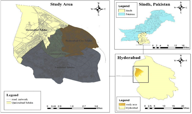
Note. Source: Abbasi et al. (2019)
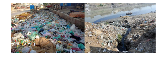
Figure 2
Water Channel (Wadhu Wah) Qasimabad, Hyderabad

The waterway is more than eight km long and is known as the Wadhu Wah distributary. It emerges from the Phuleli Canal. However, the three-kilometer section that goes through Qasimabad is clogged with muck (Nnaji et al., 2024). Two main roadways run transverse over densely inhabited private colonies and loft buildings on each side of the distributary. The residents of all of these so-called wealthy regions in Qasimabad experience several issues due to the drainage system and rain (Khoso et al., 2018).
The Qasimabad municipal officials have been dumping heavy garbage on a plot of land. An eight-to-ten-acre tract of land, bounded by the sports complex, is now functioning in the community for the disposal of trash, where huge volumes of waste are deposited and devoured every day. Many people live in these formal residential areas (Sahito & Memon, 2016).
Figure 3
Heaps of Garbage in Qasimabad Sports Complex
Literature Review
According to UNHABITAT, during the past 50 years, Asia has seen huge demographic changes (Helble, et al., 2021). One of these changes is the transfer of people from rural to urban regions, which is why the percentage of people living in urban areas is rapidly rising (Bhattacharjee et al., 2021). Only 17% of Asia's total population—232 million people—lived in cities in 1950. The urban population increased to 1.6 billion in 2005, accounting for 40% of Asia's overall population. The United Nations has projected that by 2025, more than 50% of Asia's population will reside in cities, with this number rising to 54.5% by 2030 (Opondo et al., 2023). Three factors contribute to this significant rise in urban population: natural population growth, rural-to-urban migration, and reclassifying rural areas as urban areas. It was discovered that while the number of urban inhabitants is growing, 37% of the world's population still resides in slums as a result of widespread rural-urban movement and emigration from smaller to larger cities (Doytsher et al., 2010).
Residents of slums have minimal access to public services, such as healthcare and education. One-third of the population of Dhaka lives in slums, where a lack of access to basic amenities, inadequate water supply, and inadequate waste disposal contribute to a variety of health issues (Fatemi et al., 2020). According to a 2012 United Nations estimate, 533 million people, or 42% of all metropolitan Asians, live in slums. The majority of these individuals are regular and hardworking people who cannot afford requisite housing (Pugh et al., 2000). According to Potsiou and Doytsher (2010), and Pugh (2000), 30% of the urban population in developing nations lives in slums or other informal settlements. Sub-Saharan Africa's slums constitute around 90% of all new urban settlements. Moreover, these are frequently constructed in high-risk and hazardous areas that might be affected by climate change. According to Hussain et al. (2019), katchi abadis emerge on the periphery of major cities or next to high-income residential areas for economic reasons. According to a report published by UNHSP and UNESCAP, informal settlements in Asian cities might be of any size or shape (Winarso, 2022). However, they always share a highly dynamic reaction to the complete absence of alternatives. The urban migrants from the countryside carried their felt-lined tents with them to Mongolia. Approximately, 55% of people in Mumbai, India, live in slums, and many of them cannot afford to buy their own houses there (Xu et al., 2021). Thirty-five (35000) households in Manila, the Philippines, collect recyclable rubbish for a living, yet still have to live in substandard housing. Slums that are located alongside railway tracks and waterways are where Thailand's poor urban population is compelled to dwell (Sapuay, 2016).
Causes of Slum Conditions
In the past 15 years, slums have expanded at an unprecedented rate. These areas are becoming a prominent and distinctive kind of habitation in many cities in the developing world (Demehin, 2022; United Nations Human Settlements Programme, 2010). Through the greatest annual slum and urban growth rates (4.53% and 4.58%, respectively) essentially similar, urbanization has practically become synonymous with slum growth. Zhang (2018) World Progress Report, described slum growth as an unavoidable "growing pain" of economic progress, in contrast to past approaches regarding slums that characterized them as unlawful settlements to be removed (Khalifa, 2015).
Rapid Urbanization
Cities are growing at a faster rate than they can accommodate the number of people moving from rural regions and because of this, especially in emerging nations infrastructure, services, and housing are in short supply (Roberts et al., 2019). Unplanned population growth causes many cities to become unprepared which results in the unplanned development of informal settlements without appropriate zoning or urban planning (Cobbinah et al., 2023).
Rural-to-Urban Migration
People move to urban areas in search of employment, to acquire higher education and a better quality of life. However, cities frequently fall short of providing sufficient infrastructure and cheap housing, forcing newcomers to reside in slums. Economic issues in rural areas, such as decreased agricultural output or lack of work, push people to transfer to metropolitan centers which are unable to absorb them efficiently (King et al., 2017).
Poverty and Economic Inequality
Slum dwellers frequently work in the informal economy (e.g., street vending, domestic work) and make poor salaries. It is difficult for them to afford decent accommodation due to their low salary (Smith et al., 2019). Widening differences between the affluent and poor in metropolitan regions intensify slum conditions, as wealthier individuals live in well-developed districts while lower populations are marginalized and forced into inadequate living circumstances (Rains et al., 2020).
Land Tenure and Legal Issues
Many people who live in slums are not the legitimate proprietors of the land they occupy. Therefore, they are hesitant to renovate their homes without clear land rights, and governments may not want to build infrastructure at places they view as illegal (Nzau et al., 2020). Urban land may occasionally be the target of speculation by developers or wealthy individuals which could result in evictions or make it impossible for low-income households to purchase land for habitation (Gemeda et al., 2019).
Housing Challenges and Issues in Pakistan's Urban Areas
Sprawl is expanding exponentially in emerging nations and it is currently considered as the modern trend of the current globalized sphere. This tendency is advancing at a faster pace due to revolutionary technologies (Talkhabi et al., 2022). People are being encouraged to travel and leave their houses as a result of this new modernizing practice. Moreover, people are interested in learning how this significant development is influencing the world since everything has both good and bad effects. In particular, the continent where one may see the fastest rate of urbanization is Asia (Malik & Wahid, 2014).
Since no country can tolerate any disruption in the growth of economic advancement, urbanization cannot be completed. If the housing problem is not addressed properly and on time, it would only get worse (Baig et al., 2020). The dream of adequate and proper housing for the inner-city poor can become a reality if their current settlements are managed with thoughtful planning and oversight, along with the effective implementation of development policies under competent administration (Sufyanullah et al., 2022).
Materials and Methods
Due to rising urbanization and the limited capacity of government systems to provide essential living accommodations for rural migrants in metropolitan centers, Pakistan has developed extensive slum areas, similar to those in many other developing nations (De Dominicis et al., 2022).
Figure 4
Population Living in Slums
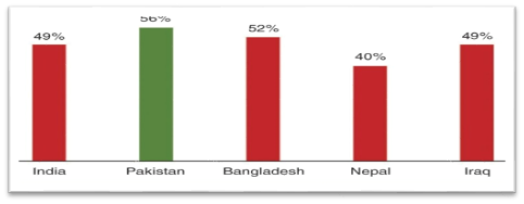
Note. Source: (Hasan et al., 2021).
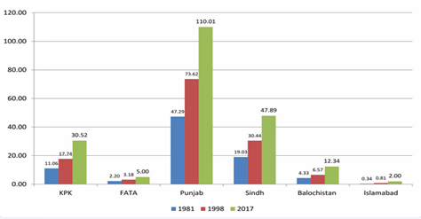
Pakistan's urban population has increased at a faster pace between 1950 and 2017 and is expected to continue growing between 2000 and 2050 (Mazhar & Jamal, 2018).
Figure 5
Demographic and Urban Development (1981-2017)
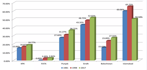
Figure 6
Demographic Figure of the Population in Pakistan
Note. Source: (Wazir & Goujon, 2021).
Sindh has the second-highest development rate in Pakistan. Hyderabad, one of the fastest-growing cities in Sindh, has seen tremendous industrialization, with Qasimabad covering more than 49,800 acres of land including more than 250 housing developments as well as 70 katchi abadis, or impromptu communities (Marvi et al., 2024).
Furthermore, it was also determined that Qasimabad, Hyderabad, was the most affected area in terms of allocating land for social welfare. This is because such activities were hardly observed by the respondents in the study area. Qasimabad taluka is a highly valued area of Hyderabad. It is the third largest urban center of Hyderabad, Sindh, with a population of over 0.4 million (Ibrahim et al., 2021). These communities consume the most hazardous environmental conditions, which are shown by a lack of water supply, filthy conditions of natural sanitation, crowded and weathered housing, risky location, and weakening of residence, as well as difficult economic and social conditions (Abbasi et al., 2019). Designing a map for unplanned neighborhoods or slums offers essential insights into their characteristics, demographics, and spatial distribution. This kind of mapping serves multiple purposes, such as identifying infrastructural gaps, planning for service delivery, addressing socio-economic challenges, and aiding urban development projects (Muller et al., 2020).
Qasimabad taluka was chosen as a case study. It is located in the western section of Hyderabad. This case study examined how different commuters observe current trends in urban land use planning. It is situated at coordinates 25.24 oN latitude, and 68.20 oE longitude (Shaikh et al., 2019). The site has a total size of around 49,800 acres which includes both built and undeveloped land. Additionally, it is administratively separated into four Union Councils, with Qasimabad serving as its administrative center (Canton, 2021).
Results
The main objective of this study was to investigate the existing state of the physical environment, site planning, social and economic challenges, as well as land use activities and the development of practical solutions to stop the growth of slums. The data collection of the current study required active document examination and individual opinion.
The secondary data gathered from census reports, grasp formats, and other reports was used to thoroughly analyze the growth patterns of the area under study in Qasimabad, Hyderabad. The researcher also traveled to the case study locations to observe the living standards of people residing there.
With 3508 acres of land converted, Qasimabad district in Hyderabad Development Authority (HDA) is one of the most significant districts in terms of agricultural land conversion, followed by Latifabad district with 1064 acres. The results also showed that Hyderabad is expanding over time, with Qasimabad district serving as the key economic hub for 3508 acres of priceless agricultural land during the past ten years.
Figure 7
Change in Acres of Agricultural Land during the Last 10 Years
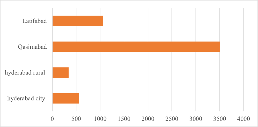
Table 1
Population of Hyderabad during Six Censuses
|
Area Name |
Population |
|
|
|
|
|
Growth rate % |
|
|
1951 |
1961 |
1972 |
1981 |
1988 |
2017 |
|
|
Hyderabad District(overall) |
625,848 |
93199 |
1,623,864 |
2,022,305 |
2,834,451 |
2,908,147m |
3.6 |
|
Hyderabad city Sub-District |
242,651 |
436,171 |
630,624 |
394,853 |
525,299 |
538,957 |
1.2 |
|
Qasimabad Sub-District |
3370 |
5225 |
9448 |
32043 |
115,374 |
118,374 |
34.1 |
|
Latifabad Sub-District |
3780 |
7968 |
14,517 |
366,799 |
563,761 |
578419 |
152 |
|
Hyderabad rural Sub-District |
69,431 |
87,636 |
159,471 |
211,765 |
290,432 |
197,983 |
3.3 |
Table 1 demonstrates the 3.6 times (360%) growth rate in population for the Hyderabad district between 1951 and 2017. With 34.1 times (3410%) rise rate (Peerzado et al., 2019) for Qasimabad.
Figure 8
Growth Rate of Hyderabad during Six Censuses
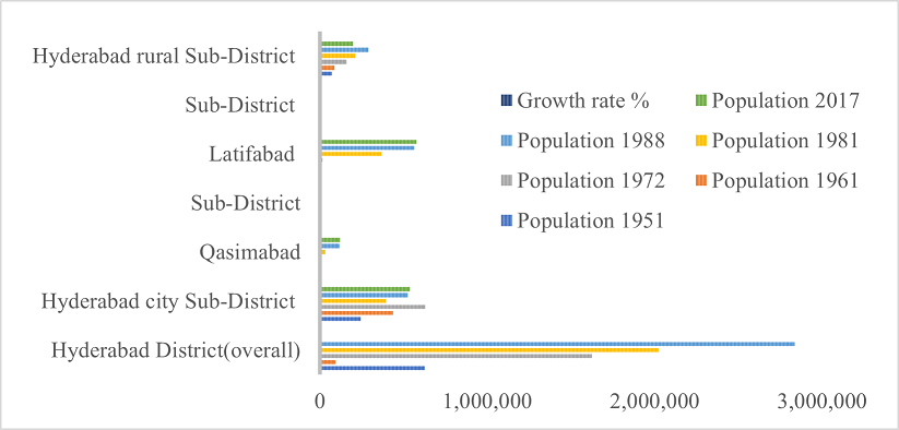
Figure 9
Area and Population Density of Pakistan's Largest Cities
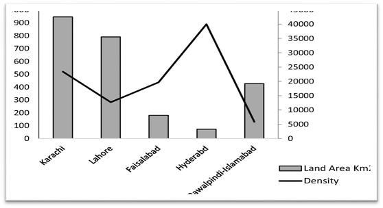
With 40,000 persons per km2, Hyderabad has the highest population density in the country (see Fig. 8). Additionally, according to government figures, Hyderabad is one of the most densely inhabited areas in the country with a 3.6 growth rate in population. Additional population growth trends are also available.
Table 2
Sub-emergence of Agricultural Lands into Urbanization
|
Particulars |
Agriculture land sold/acre Total |
Sold |
|
Hyderabad city Sub-District |
30 |
21 |
|
Qasimabad Sub-District |
32 |
31 |
|
Latifabad Sub-District |
16 |
11 |
|
Hyderabad rural Sub-District |
26 |
9 |
|
Overall Hyderabad District |
104 |
72 |
Figure 10
Clustered Bar Chart of Agricultural Lands into Urbanization
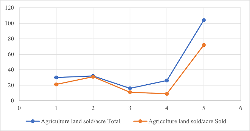
According to Table 2, Qasimabad leads the way in property transformation with an average rate of 97%, followed by Hyderabad City with 70%, Latifabad with 69%, and rural Hyderabad with 35%. While 70% of agricultural property was exchanged and altered in urban areas. People exchanged their non-industrialized property for cash, communal, commercial, and agricultural purposes.
People relocate to adjacent areas where land costs are affordable for middle-class residents when prices rise, however, are still close to urban areas yet outside of the urban boundaries. These lands are a part of rural areas that were once utilized for agriculture, however, with suburbanization, these lands are now used for schools, markets, and transportation.
Figure 11
Urban Land Conversation to Urban Sprawl
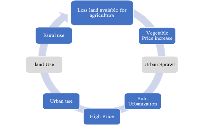
Additionally, the governments have to pass legislation limiting the use of new agricultural land for urbanization and mandating the construction of housing developments where there is no agricultural land.
Figure 12
Unplanned Settlements in Qasimabad District
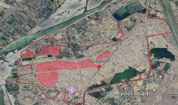
Figure 12 shows unplanned neighborhoods, sometimes known as slums, shantytowns, or informal settlements, in the Qasimabad district. The lack of essential infrastructure and services in these communities may result in poor living conditions for the locals. Due to their location and inadequate infrastructure, these communities are especially at a risk of disasters, such as landslides and floods.
Discussion
There are several interrelated reasons for the development and growth of slums in Qasimabad and other Pakistani cities. These include issues with government, insufficient urban planning, economic inequality, and fast urbanization. The migration of the rural population to urban areas, such as Qasimabad, in search of greater economic prospects, is one of the main factors contributing to the establishment of slums. Lack of investment and water scarcity are the common problems in rural Sindh's agriculture which drives people into the metropolis (Hafeez et al., 2020). Population growth and informal settlements are the outcomes of infrastructural development not keeping up with the rapid population expansion in cities, such as Qasimabad. A considerable segment of the populace migrating to metropolitan areas is impoverished. They live in slums or informal settlements where housing is less expensive, however, lacks basic facilities since they are unable to pay for decent housing or basic utilities (Khoso et al., 2018).
Both the public and private sectors have not done enough to invest in affordable housing. The majority of low-income migrants settle in unofficial regions since they are unable to afford living in metropolitan districts. Climate change-related extreme weather events and recurrent floods in Sindh force rural communities into urban areas (Okoro et al., 2023).
When these people migrate to the cities, they frequently end up living in slums since they cannot afford decent accommodation. To enhance urban management in rapidly expanding places, such as Qasimabad, local governments, civil society, and international development agencies must work together to address these concerns (Wakely, 2018).
Conclusion
A slum redevelopment plan requires a lot of political determination from management and harsh buy-in from society. Additionally, it supports citywide improvement projects and partners from outside the slums which is crucial for execution. Slum development requires a comprehensive civilization plan with all necessary amenities, such as water and power supply, hygienic conditions, and concrete infrastructure in the early months of the year. A complete plan that incorporates urban planning, poverty reduction, affordable housing projects, increased access to essential amenities, and community empowerment is needed to address the root causes of slums in Qasimabad urban districts. Slum relief and urban development can also be aided by initiatives to increase land tenure security, enforce laws, and address socioeconomic inequities.
Conflict of Interest
The author of the manuscript has no financial or non-financial conflict of interest in the subject matter or materials discussed in this manuscript.
Data Availability Statement
The data associated with this study will be provided by the corresponding author upon request.
Funding details
This research did not receive grant from any funding source or agency.
Bibliography
- Abbasi, S., Lashari, Z. A., & Mangi, M. Y. (2019). Impacts of illegal and expedient development on built environment. VW Engineering International, 1(1), 11–16. https://doi.org/10.36297/vw.jeit.v1i1.12
- Agyabeng, A. N., Peprah, A. A., Mensah, J. K., & Mensah, E. A. (2022). Informal settlement and urban development discourse in the Global South: Evidence from Ghana. Norsk Geografisk Tidsskrift-Norwegian Journal of Geography, 76(4), 242–253. https://doi.org/10.1080/00291951.2022.2113428
- Ali, A., Talpur, A. H., Shaikh, F. A., Soomro, M. A., & Khokhar, N. (2022). A GIS-based analysis of urban extension and land use land cover change detection in Qasimabad, Hyderabad. International Research Journal of Modernization in Engineering Technology and Science, 4(7), 474–479.
- Baig, M. S. R., Nawaz, H. M. U., & Idrees, R. Q. (2020). Housing for all: A case study of Karachi Abbadis (Slums) in achieving the goal of housing for all in Pakistan. Orient Research Journal of Social Sciences, 5(2), 32–44.
- Bhattacharjee, N. V., Schaeffer, L. E., & Hay, S. I. (2021). Mapping inequalities in exclusive breastfeeding in low-and middle-income countries, 2000–2018. Nature Human Behaviour, 5(8), 1027–1045. https://doi.org/10.1038/s41562-021-01108-6
- Brunetta, G., & Salata, S. (2019). Mapping urban resilience for spatial planning—a first attempt to measure the vulnerability of the system. Sustainability, 11(8), Article e2331. https://doi.org/10.3390/su11082331
- Canton, H. (2021). United nations human settlements programme—UN-Habitat. In H. Canton (Ed.), The Europa directory of international organizations: 2021 (pp. 234–240). Routledge.
- Cobbinah, P. B., & Finn, B. M. (2023). Planning and climate change in African cities: Informal urbanization and ‘Just' urban transformations. Journal of planning literature, 38(3), 361–379. https://doi.org/10.1177/08854122221128762
- Das, G., Qureshi, S., Shaikh, F. A., Bhelar, M. G., & Talpur, M. A. H. (2021). Travel accessibility criterion of urban commuters: Evidence from Hyderabad, Pakistan. Sir Syed University Research Journal of Engineering & Technology, 11(1), 36–41. https://doi.org/10.33317/ssurj.360
- De Dominicis, L., Dijkstra, L., & Pontarollo, N. (2022). Why are cities less opposed to European integration than rural areas? Factors affecting the Eurosceptic vote by degree of urbanization. Cities, 130, Article e103937. https://doi.org/10.1016/j.cities.2022.103937
- Demehin, M. O. (2022). Urbanization, urban-slum settlements and its implications on health: An insight from Lagos State, Nigeria. International Journal of Social Sciences: Current and Future Research Trends, 13, 117–132.
- Doytsher, Y., Kelly, P., Khouri, R., McLaren, R., & Potsiou, C. (2010, April 11–16). Rapid urbanization and mega cities: The need for spatial information management [Paper presentation]. Proceedings of FIG International Congress. Sydney, Australia.
- Ezeh, A., Oyebode, O., Satterthwaite, D., Chen, Y. F., Ndugwa, R., Sartori, J., Mberu, B., Melendez-Torres, G. J., Haregu, T., Watson, S. I., Caiaffa, W., Capon, W., & Lilford, R. J. (2017). The history, geography, and sociology of slums and the health problems of people who live in slums. The Lancet, 389(10068), 547–558.
- Fatemi, M. N., Okyere, S. A., Diko, S. K., Kita, M., Shimoda, M., & Matsubara, S. (2020). Physical vulnerability and local responses to flood damage in peri-urban areas of Dhaka, Bangladesh. Sustainability, 12(10), Article e3957. https://doi.org/10.3390/su12103957
- Fatima, W. (2023). The impact of urban expansion and sustainable farming practices in agricultural sector of Pakistan. Pakistan Journal of Social Research, 5(4), 16–23. https://doi.org/10.52567/pjsr.v5i04.1328
- Gemeda, B. S., Abebe, B. G., Paczoski, A., Xie, Y., & Cirella, G. T. (2019). What motivates speculators to speculate? Entropy, 22(1), Article e59. https://doi.org/10.3390/e22010059
- Hafeez, A., Shaikh, S. S., & Qureshi, Z. A. (2020). Measuring female contribution in urban poverty reduction: A perspective from informal sector. International Research Journal of Arts and Humanities, 48(48), 137–153.
- Hasan, S. M., Das, S., Hanifi, S. M. A., Shafique, S., Rasheed, S., & Reidpath, D. D. (2021). A place-based analysis of COVID-19 risk factors in Bangladesh urban slums: A secondary analysis of World Bank microdata. BMC Public Health, 21, 1–6. https://doi.org/10.1186/s12889-021-10230-z
- Helble, M., Lee, K. O., & Arbo, M. A. G. (2021). How (Un) affordable is housing in developing Asia? International Journal of Urban Sciences, 25(sup1), 80–110.https://doi.org/10.1080/12265934.2020.1810104
- Holzbauer, Y., & Thamsen, P. U. (2022, August 3–5). Usage of clear water pumps in wastewater treatment plants–field study [Paper presentation]. ASME 2022 Fluids Engineering Division Summer Meeting. Toronto, Canada.
- Hussain, M., & Mahmud, I. (2019). PyMannKendall: A python package for non parametric Mann Kendall family of trend tests. Journal of Open Source Software, 4(39), Article e1556. https://doi.org/10.21105/joss.01556
- Ibrahim, M. N., & Khan, S. A. (2021). Sindh Agricultural Growth Project–Livestock: Project completion report. International Livestock Research Institute. https://cgspace.cgiar.org/server/api/core/bitstreams/c39ba41d-cc9a-40f6-ac29-e3faaf381483/content
- Khoso, A. R., Memon, A. H., Pathan, A. A., & Akhund, M. A. (2018). Solid waste management: practices and problems of Hyderabad city. Mehran University Research Journal of Engineering and Technology, 37(3), 653–662. https://doi.org/10.22581/muet1982.1803.18
- Khalifa, M. A. (2015). Evolution of informal settlements upgrading strategies in Egypt: From negligence to participatory development. Ain Shams Engineering Journal, 6(4), 1151–1159. https://doi.org/10.1016/j.asej.2015.04.008
- King, R., Orloff, M., Virsilas, T., & Pande, T. (2017). Confronting the urban housing crisis in the global south: adequate, secure, and affordable housing. World Resources Institute. https://smartnet.niua.org/sites/default/files/resources/towards-more-equal-city-confronting-urban-housing-crisis-global-south.pdf
- Malik, S., & Wahid, J. (2014). Rapid urbanization: Problems and challenges for adequate housing in Pakistan. Journal of Sociology and Social Work, 2(2), 87–100. http://doi.org/10.15640/jssw.v2n2a6
- Marvi, H., Kalwar, S., Talpur, M. A. H., Memon, I. A., Soomro, M., & Ahsan, N. (2024). Cultivating community: Addressing social sustainability in rapidly urbanizing Hyderabad city, Pakistan. Societies, 14(9), Article e161. https://doi.org/10.3390/soc14090161
- Mazhar, F., & Jamal, T. (2018). Temporal residential growth of Faisalabad city. Journal of Scientific Research, 39(1), 59–63.
- Memon, S. R., Arain, F. J., Kaka, Z. G., Memon, A. W., & Arisar, I. (2024). Identifying the factors of slums development in urban areas of Qasimabad, Sindh Pakistan. Sir Syed University Research Journal of Engineering & Technology, 14(1), 62–68. https://doi.org/10.33317/ssurj.619
- Muller, I., Taubenböck, H., Kuffer, M., & Wurm, M. (2020). Misperceptions of predominant slum locations? Spatial analysis of slum locations in terms of topography based on earth observation data. Remote Sensing, 12(15), Article e2474. https://doi.org/10.3390/rs12152474
- Nnaji, C. C., Udokpoh, U. U., & Ifeakor, A. R. (2024). Assessing the efficiencies of domestic water pumps and distribution systems for household water supply in Enugu State, Nigeria. Indian Journal of Engineering, 21, Article e5ije1680. https://doi.org/10.54905/disssi.v21i55.e5ije1680
- Nzau, B., & Trillo, C. (2020). Affordable housing provision in informal settlements through land value capture and inclusionary housing. Sustainability, 12(15), Article e5975. https://doi.org/10.3390/su12155975
- Okoro, C., Olaleye, A., & Owojori, O. (2023). The risks of private sector investment in affordable housing development: An Afrocentric perspective. Journal of Infrastructure, Policy and Development, 8(1), Article e2691. https://doi.org/10.24294/jipd.v8i1.2691
- Opondo, E. O., Ajayi, D. D., & Makindi, S. M. (2023). Impacts of quarrying activities on the environment and livelihood of people in Border II sub‐location, Nyando sub‐county, Kisumu County, Kenya. Environmental Quality Management, 32(3), 147–160. https://doi.org/10.1002/tqem.21881
- Peerzado, M. B., Magsi, H., & Sheikh, M. J. (2019). Land use conflicts and urban sprawl: Conversion of agriculture lands into urbanization in Hyderabad, Pakistan. Journal of the Saudi Society of Agricultural Sciences, 18(4), 423–428. https://doi.org/10.1016/j.jssas.2018.02.002
- Potsiou, C., & Doytsher, Y. (2010). Urban management: Availability of technical tools [Paper presentation]. Proceedings of International Conference SDI. Skopje, Macedonia.
- Pugh, K. R., Mencl, W. E., Jenner, A. R., Katz, L., Frost, S. J., Lee, J. R., Shaywitz, S. E., & Shaywitz, B. A. (2000). Functional neuroimaging studies of reading and reading disability (developmental dyslexia). Mental Retardation and Developmental Disabilities Research Reviews, 6(3), 207–213. https://doi.org/10.1002/1098-2779(2000)6:3%3C207::AID-MRDD8%3E3.0.CO;2-P
- Qurban, S. (2024). Education policy and the construction of neo-liberal citizenship in Pakistan: Revisiting the Musharraf Era, 1999-2008. Routledge.
- Rains, E., & Krishna, A. (2020). Precarious gains: Social mobility and volatility in urban slums. World Development, 132, Article e105001. https://doi.org/10.1016/j.worlddev.2020.105001
- Roberts, M., Sander, F. G., & Tiwari, S. (Eds.). (2019). Time to ACT: Realizing Indonesia's urban potential. World Bank Publications.
- Sahito, N., & Memon, I. A. (2016, November 1–3). Urbanization and secondary cities of Sindh province: Towards more effective and sustainable cities [Paper presentation]. Proceedings of the 4th International Conference on Energy, Environment and Sustainable Development. Jamshoro, Pakistan.
- Sapuay, G. P. (2016). Resource recovery through RDF: Current trends in solid waste management in the Philippines. Procedia Environmental Sciences, 35, 464–473. https://doi.org/10.1016/j.proenv.2016.07.030
- Shaikh, S., Talpur, M. A. H., Baig, F., & Ogahi, M. A. (2019). Setback violation and residents' perception about living conditions in vertical buildings of Qasimabad, Hyderabad. Journal of Art, Architecture and Built Environment, 2(1), 1–15. https://doi.org/10.32350/jaabe.21.01
- Siddiqui, S. A. (2024). Islam, poverty, and philanthropy in the global south. In S. C. Sullivan, S. Offutt, & S.A. Siddiqui (Eds.), Religion and poverty (pp. 114–141). Routledge.
- Singh, S. (2021). Understanding slums: In time and space. International Public Health Journal, 13(2), Article e133.
- Smith, T. A., & Brown, A. (2019). Community-led housing and urban livelihoods: Measuring employment in low-income housing delivery. Habitat International, 94, Article e102061. https://doi.org/10.1016/j.habitatint.2019.102061
- Sufyanullah, K., Ahmad, K. A., & Ali, M. A. S. (2022). Does emission of carbon dioxide is impacted by urbanization? An empirical study of urbanization, energy consumption, economic growth and carbon emissions-Using ARDL bound testing approach. Energy Policy, 164, Article e112908. https://doi.org/10.1016/j.enpol.2022.112908
- Talkhabi, H., Ghalehteimouri, K. J., Mehranjani, M. S., Zanganeh, A., & Karami, T. (2022). Spatial and temporal population change in the Tehran metropolitan region and its consequences on urban decline and sprawl. Ecological Informatics, 70, Article e101731. https://doi.org/10.1016/j.ecoinf.2022.101731
- United Nations Human Settlements Programme. (2010). State of the world's cities 2010/2011: Bridging the urban divide. https://unhabitat.org/state-of-the-worlds-cities-20102011-cities-for-all-bridging-the-urban-divide
- Wakely, P. (2018). Housing in developing cities: Experience and lessons. Routledge.
- Wazir, A., & Goujon, A. (2021). Exploratory assessment of the census of Pakistan using demographic analysis. Journal of Official Statistics, 37(3), 719–750. http://dx.doi.org/10.2478/JOS-2021-0032
- Winarso, H. (2022). Slum-upgrading through physical or socio-economic improvement? lessons from Bandung, Indonesia. Journal of Housing and the Built Environment, 37(2), 863–887. https://doi.org/10.1007/s10901-021-09859-4
- Xu, Y., Zhang, Y., & Chen, J. (2021). Migration under economic transition and changing climate in Mongolia. Journal of Arid Environments, 185, Article e104333. https://doi.org/10.1016/j.jaridenv.2020.104333
- Zhang, Y. (2018). The credibility of slums: Informal housing and urban governance in India. Land Use Policy, 79, 876–890. https://doi.org/10.1016/j.landusepol.2017.05.029