Exploration of Tools and Techniques for Studying the Tangible and Intangible Aspects of Urban Settlements: Evidence from a Postgraduate Design Studio
Mamuna Iqbal*, Usman Awan, and Madiha Zaman
University of Engineering and Technology, Lahore, Pakistan
Abstract
This research study investigates the tangible and intangible aspects of the urban settlement and explores the tools for it. It was based on a post-graduation design studio named Understanding Urban Settlement, which is part of the Masters in Architecture program at a leading university in Lahore, Pakistan. The research is based on the exploratory methodological approach to attain a deep understanding of the social, cultural, environmental and religious characteristics of the Walled City of Lahore. It further explored the effects of these aspects and the way they affect the built environment, particularly the urban squares. The characteristics of the urban squares became the central part of the study through the research question formulated by students. The tools of space syntax and depth map and the approaches of psychogeographic analysis, systems thinking, and giga mapping were applied. These three approaches make the three sections of the exploratory methodology. Furthermore, the tools helped to understand various aspects of the city, where space syntax helped to explore the tangible character of the built environment and psychogeographic analysis helped to comprehend the intangible nature of social character in the city. Systems thinking and giga mapping are used to grasp and make sense of all the data gathered through the first two tools. The results showed that using these tools not only provides the framework to understand the most complex urban scenarios but also helped to triangulate the information through different sources. Based on the work of the students and their feedback about the three explored tools, it became evident that these approaches helped them to visualize the city under a new light and made the most complex urban scenarios a little more comprehensible. It also showed that the intangible and tangible characteristics of a city are co-dependent and exploring the social and cultural aspects of a city helps to develop a deeper and complete understanding of the spatial character of a city.
Introduction
Understanding an urban settlement is a task that can take many different directions as the comprehension of complex nature of urban settlements requires a careful and deep exploration of tools and techniques that go beyond the conventional approaches. It demands experimentation with different methods and constant improvement through reflection. This research explains the methods and approaches of an urban design course which encompasses approaches towards diversified tools and experimentation to report its findings. These methods are psychogeography, space syntax, and systems thinking.
The site where these tools are being used is the Walled City of Lahore that is a centuries old development in the heart of the city. This site is of great significance, it is a complex multilayered urban and social setup with a very important historical background. Its rich character of built and unbuilt heritage is an ideal case study for the exploration of the multifaceted ideas. The use of the concepts of psychogeography, space syntax, and systems thinking to understand the multilayered complex spatial, social, and cultural character of the Walled City is a novel approach that helps to explore the context from a unique perspective. Additionally, it will also help to expand the understanding of these concepts.
This study is focused on exploring the above-mentioned tools and critically reflecting upon their implementation, due to the limitations of the current research framework based on the timeline for the course, as well as the accessibility to the defined zones, it does not cover the results from these tools for all of the Walled City except for specified areas and zones. However, some examples of the analysis are shared to understand the practical application of tools.
Psychogeography and Derive
Psychogeography is a very important concept and approach that goes beyond the traditional methodological approaches. It is a fundamental theory that sets the framework to explore the relationship of built environment and human emotions and experiences based on the defined social factors (Careri, 2017). It explores the relationship of individuals and groups with physically built spaces and helps to understand the city from the perspective of its user (Smith, 2010). Thus, psychogeography builds our perception of the city by allowing us to see beyond the obvious.
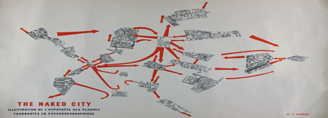
The concept of psychogeography is rooted in the idea of derive which literally means to drift. The term drift means to walk through the city with an aim to define its unconscious zones. The idea of derive was introduced by Situationist International (1957-1972), as an attempt to challenge the consumer culture taking roots after World War II and engage with the built environment in a meaningful manner. Guy Debord, a founding member of Situationist International, explained the importance of derive in his book "Society of Spectacle" (1987). He identified derive as a tool to engage with the city and find the moments of truth. He along with his associates conducted several walks in Paris and documented their new perceptions through the non-traditional mapping techniques. Debord developed a map of Paris through his psychogeographic observations in 1957 and termed it as "The Naked City" (Sadler, 2017) as shown below in the Figure 01. This map became a symbol to be followed by the psychogeographers for decades. In "The Naked City", printed maps of Paris using the aforementioned techniques, Debord delves into the urban landscape and how cities shape and control the lives of their inhabitants (1956). Hence, this idea of psychogeography is rooted in the artistic movement "Situationist International".
Figure 1
The Naked City by Guy Debord
Urban places are the geographical locations that have a psychological character studied through the people inhabiting it (Bassett, 2004). Psychogeographers investigate this character by understanding the built infrastructure, architecture, public spaces, landmarks, transportation network, and the incorporation of nature in the urban environment (Wollen, 2001). They explore how these various aspects impact the lives of people in a deep and profound manner (Ellard, 2018). This notion takes the idea of city from being a lifeless object to a living organism that shares the life with its occupants and is mutually affected by different phenomena. Based in 1970s Paris, Situationists believed that we have turned into a "Society of Spectacles", as we are too much focused on showing rather than being, and this is pushing us into a shallow existence (Debord, 1987). They identified that in order to rectify this, the society needs to connect with itself and see beyond mere spectacles. They proposed "Derive" as a way to uncover the hidden aspects of the city for it means to drift from the urban landscapes without any clear agenda and allow ourselves to go beyond the spectacles of the city. It is a way of challenging the conventional ideas of space and to allow the body and environment to connect with a goal of creating and attaching new meaning to the space. Derive identifies walking as a transformative agent that allows a deeper connection with our environment and provides new insights and knowledge for the spaces we have always lived in but never really saw. Therefore, derive is a tool for psychogeography and is used as a method to explore the relationship of the city with its inhabitants (Careri, 2017).
Space Syntax and Depth Map
In contrast to the conceptual and philosophical way of engaging with a city, the theory of space syntax provides a very technical and methodological approach for exploring a city. Based on the conceptual idea of cities as a social system, space syntax provides the tools and techniques to study this social system (Griffiths, 2017). It explores the relationship of human behavior with the physical layout of the space. The concept of space syntax was first developed at the Bartlett School of Architecture by the two pioneers Hiller and Hanson (1986). They developed this theory as an attempt to understand the most complex built environment in a systematic way.
Since its conception, space syntax has a wide range of uses in interior design, architecture, urban design, and sociology (Hillier, 2007). Within a city, it has a number of implementations, such as studying the pedestrian network, traffic pattern, and everything related to human lives, including social, cultural, and economic factors. These studies help to design an environment that is user friendly and helps to improve the lives of people residing in the city (Refaat, 2019). Space Syntax achieves this by understanding the mathematical relationships of space as a system and the data on pattern of activities in the space. Hillier argued that it is the responsibility of designers to understand how built environments actually work before suggesting on how they should work. Moreover, in order to understand the cities, it is important to understand the structure of activities.
The structure of activities is often associated with the idea of integration and connectivity within a city which is studied through the concept of depth in a city. Spaces with higher depth are often well integrated and connected as compared to the spaces with low depth. The software "depth map" was developed by Hillier and Hanson to explore these mathematical calculated values. This software is based on the theories of space syntax and function to explore the physical relationship within a city. However, the researcher has to do the interpretation of such relationships and how they translate into human activity patterns by engaging in critical examination of the space and that is where psychogeography will help.
Systems Thinking and Giga Mapping
Often designers have a big set of data that is collected through different sources however, it becomes difficult to find connections within such extensive data. In this respect, the approach of Systems thinking helps as it focuses on exploring the underlying connections in large set of data and has a variety of implementation. It is not a directly relevant concept to urban design, but it is important for this study because it helps to find connections in variety of data forms. It is considered as a holistic approach to solving complex problems often involving real-life situations (Sevaldson, 2013). Beginners to systems thinking often deal it merely as a tool, something that helps to create loops and connective diagrams however, systems thinking is much more than this. It is an underlying philosophy which is based on the belief that the world we live in has some strong underlying structures that are often not immediately visible and there are consequences to our actions. Systems thinking helps us to define such structures by acting as a tool. It often begins with collecting data and observing social systems or events and moves on to finding patterns and systems and underlying structures that define those patterns (Ryan, 2014).
Whereas, giga mapping is the tool to implement systems thinking and is an innovative way for visual representation of data and to find connection and relations within this data (Sevaldson, 2011). A giga map is typically a collection of different forms of complex data including but not limited to photographs, sketches, notes, diagrams, interviews, color coded ideas, and results of surveys (Sevaldson, 2011). By putting all of this data together in one map and by analyzing it through exploring relationships and interconnections helps in identifying the underlying systems. It also helps to understand this complex data through an accessible and visually engaging graphical representation.
Giga maps are used in various fields of study both in academia and practice to conduct the organizational analysis, problem solving, and strategic planning. It is often used as a way of communication within stakeholders, done through the exploration of complex ideas. It facilitates collaboration with a large group of designers by providing insight into the underlying systems, synchronizing systems thinking through improvision into its users (Sevaldson, 2017).
Significance of the Walled City of Lahore: Ground for the Exploration
The Walled City of Lahore is one of the most historically significant built heritage in the world with very rich social, cultural, and historic character (Rana & Bhatti, 2018). It possesses a very complex urban fabric with multiple layers of historic and contemporary interventions. It also has a history of cultural exchange under the reign of several rulers belonging to different religions, under the British rule, and finally after independence it transformed into a bustling business hub. The Walled City is home to a very dense urban population, many of them are migrants from other cities who came here looking for work and then stayed. Being the center of many wholesale businesses as well as hub for many small industries, the Walled City provides diversified work opportunities to a larger workforce across the city. This makes the Walled City as one of the most unique setting that is both culturally rich and socially complex. This is the reason that the Old City has attracted a large number of scholars, researchers, and enthusiasts alike (Haroon et al., 2019).
As the city evolved through time, it has been confronted with many challenges, including social disparities, rapid commercialization, unplanned urbanization filled with illegal encroachments, and a loss of cultural identity and built heritage (Gulzar, 2017). Moreover, being an organically developed city over the centuries through unplanned interventions, it possesses a very complex spatial configuration. The buildings are merged together and the pathways are narrow and often covered with shading elements and terraces that in some cases obstructs the sunlight from coming down the streets. All these factors contribute to the reduced accessibility to nodes and squares that are situated deep inside the city (Zahid & Misirlisoy, 2021). Thus, these factors make this context an ideal case study for the research on urban issues.
The enormously complex urban system of the Walled City of Lahore comprises of many tangible and intangible characters. The tangible character is defined by the physical infrastructure of the city including the road networks, street patterns, traffic patterns, urban squares, buildings facades, and architectural language. On the other hand, the intangible character is defined by the features that define the soul of the city and consists of the cultural aspects, including art, language, religious believes, clothing, customs, food, and so on. None of these tangible and intangible characters are mutually exclusive, they always co-depend on each other and studying one of it is not possible without digging deep into the other (McCandlish & McPherson, 2021). In this study, the theories of psychogeography, space syntax, and systems thinking helped to explore the complex nature and the tangible and intangible aspects of the Walled City of Lahore in terms of its spatial and social character. Details about the usage of these theories are further discussed in the methodology section below.
Methodology
This study is conducted as an academic project for the M.Arch studio in the spring of 2023. There was a total of 20 students in the class who were divided into four groups, where each group consisted of 5 students. The pedagogical model of the studio is focused on the tutor being the facilitator and students taking the charge of learning. Students were gradually introduced to the ideas of psychogeography, space syntax, and systems thinking. In the theoretical part of the studio, students explored these ideas through literature reviews and presented their understanding in the class. Discussions related to the theories were generated under the tutor's guidance to develop critical reflection and take the ideas further. Meanwhile, in the practical part of the study, students were assigned a zone of the Walled City by dividing the whole area into four zones (Figure 2). The process of studying these zones can be divided into three parts, the first is the psychogeographic analysis, the second part is the space syntax analysis, and the third part is the giga mapping under the concept of systems thinking.
Figure 2
Four Zones of the Walled City Lahore
For the psychogeographic analysis, students conducted a literature review to develop a basic understanding of the concept followed by some case studies analysis to understand its implementations. Debord himself gave a complete account of how psychogeography and derive can be conducted (Debord & Wolman, 1956). He suggested that it should be done in groups and can last for hours, days, or weeks, and the spatial field can be rigidly defined or it can be modified based on the site"s conditions and limitations. Bassett (2004) used psychogeography as an experiment to understand the city of Paris and identified that it is a method for students to get engaged with the real world in a meaningful manner. Bridger (2013) and Kelly (2020) motivated their students to use psychogeography as a method for engaging with their campuses through a unique perception and reflecting on their emotions. Kim (2021) explored the pedagogical impacts of psychogeography and suggested its importance as an urban mapping tool. In the recent years, several studies used the concept of psychogeography and derive to understand the complex infrastructure of cities. İlkay (2023) as well discusses how this approach helps to understand the feelings/sentiments of individuals attached with the city and how it shapes their perceptions. Brown and Brown (2024) conducted the psychogeographic analysis of 6 cities and reported it as an affective methodology for understanding the relationship of humans with their cities. In the current research, students explored these examples to understand more precisely how to conduct psychogeographic analysis and derive in their own sites. After thorough deliberations within the groups and with other groups, they developed plans for the analysis. For the first derive, students observed and roamed around the streets of the Walled City without any defined route and research question. After the first derive, they reflected upon and shared their experiences in the studio. As a group, they were able to share their experiences and generated meaningful outcomes. As a result of this, students after the first derive developed the following research question.
How does the spatial structures of the urban squares are playing a role in the social life of residents in the Walled City?
This research question was the same for all other groups and they explored it in their own specific zones. For the second and subsequent derives, students developed a clear research question and they also identified the routes to walk on. Each group conducted multiple derives until they covered most of the streets and roads in their zones. They used these derives and the information collected through them to develop "metagraphs". A metagraph is a graphical representation of relationship among various other graphs (Sevaldson, 2017). Therefore, in case of psychogeography, it is a graph that explores the relationship among different elements of the urban environment. The results of these derives and their metagraphs are presented in the below findings section.
The second part of this inquiry was space syntax analysis conducted on the depth-map software. Students learned and acquired the knowledge regarding the usage of the software and the the theories defined under the concept of space syntax to make sense of the maps generated by the software. Depth map is a widely used software to explore the spatial configurations and then make decisions based on it. McCahill and Garrick (2008) reviewed the bicycling paths in Cambridge, Massachusetts, and suggested improvement. Lerman et al. (2014) used space syntax to model pedestrian movement in urban transportation planning. Monokrousou and Giannopoulou (2016) interpreted and predicted pedestrian movement in public space through space syntax analysis. Recently Yunitsyna and Shtepani (2023) used these tools to study four residential complexes in Tirana, Albania to understand the correlation between the type and location of the activities and the spatial and visual integration. Students explored the researches like this to understand the usage of space syntax. They developed axial maps of the identified zones of the Walled City by using AutoCAD, imported them to depth-map and ran some analysis to generate maps. The outcome of these analyses and maps is shared in the findings section below.
Once students gathered data through derive and depth map analysis, they were asked to employ the methods of systems thinking to critically analyze it. For this analysis they used the method of systems thinking and giga mapping. Students were encouraged to develop an understanding of these ideas through the lectures and through a detailed literature review to understand the use of it in precedents. They studied the use of these ideas in previous researches to understand the complex built environments (Davidova, (2018) and Hensel and Sorensen (2019).
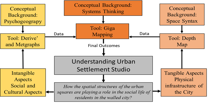
To make giga maps, they used all the different forms of data collected through the psychogeography and space syntax. This data included sketches, drawings, photographs, field notes, and drawing generated through the depth map analysis. Each student compiled all the forms of data together on a large sheet and then explored the connections within the collected data. Once all the possible connections are found, it looks like a complex mind map with factual data and complicated relationships within it, thus termed as giga map. Figure 3 shows the relationship of three parts forming the methodological framework. It shows the relationship of two tools of metagraphs and depth map with the research question and with the final outcome through a third tool, that is the giga map.
Figure 3
Methodological Framework for the Study
Findings
Findings of all three parts of the study are discussed individually here and in the discussion session and their relationship with each other is explored and critically analyzed.
Results from the Psychogeographic Analysis
We started the psychogeographic analysis of the Walled City from the Lohari Gate. We tried our best to not follow the preconceived notions and let our instincts guide us the way through the rich streets of the Walled City. We tried to embrace the idea and spirit of exploration and aimed at seeing the familiar aspects of the city with a new perspective (Group 4).
The psychogeographic analysis done through derive helped the students to understand the various aspects of the site of the Walled City and the assigned zone. It helped them to understand the social and cultural facets of the Walled City. Below are a few quotes from the students' description of psychogeographic analysis that explain how they have experienced the cultural phenomenon in the Old City.
We find the vibrant commercial activity that provides a focal point for economic exchanges and social interactions. This crowded and vibrant nature of the market creates an energetic atmosphere where individuals from diverse backgrounds come together to engage in business and social activities. These narrow passages with different sounds and smells contribute to an immersive experience that creates a sense of excitement and exploration (Group 3).
We were welcomed by the beautiful scent of loaded kiosks of flowers. Before entering through the gate, a number of shops were there, mostly single and double-story, with different kinds of signboards, trying to capture the attention of the visitors (Group 4).
This exercise also helped the students to understand the complications of the built environment. Some of their responses are mentioned down below.
Due to the numerous banners and posters hanging along the entrance road, we were barely able to see the gate itself. The main building of Lohari Gate is white with flanking bastions, marking the evidence that Lahore was once a Walled City (Group 1).
The tradition of "thara" culture still prevails, as the shops are further expanded on the streets for the display of items. Also in residential areas, these tharas are used as a sitting place in front of the houses where people often sit, interact, and socialize with neighbors (Group 3).
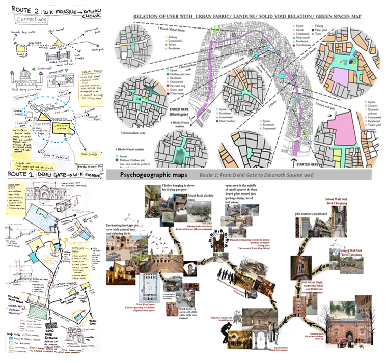
These observations were transformed into metagraphs based on a similar model as the Naked City map (Figure 1). However, since the metagraphs do not have any limit in terms of representation, students were encouraged to explore other ways of representing the psychogeographic observations. Figure 4 shows some of these metagraphs.
Figure 4
Psychogeographic Metagraphs by the Students
Results from the Depth Map Analysis
Depth map analysis is conducted to incorporate the concept of space syntax in the study. In this analysis, students created different graphs by using depth map software to understand the spatial layout and physical character of urban areas in the Walled City of Lahore. To keep the analysis simpler and more understandable in relation to other aspects of the current study, only two maps were discussed, namely connectivity and integration. These two maps generated the most significant results by all the four groups and this is the reason for their selection.
Figure 5
Connectivity Maps of Zone 3 and 4
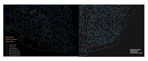
Connectivity shows how well-connected streets are with each other, the higher the level of connectivity the more well-connected those streets are. In both the maps, red colored lines show the most well-connected streets and blue shows the least connected streets and roads. Yellow and green lines show progression from most to least connected. Figure 5 shows the connectivity map of two of the four zones in the Walled City.
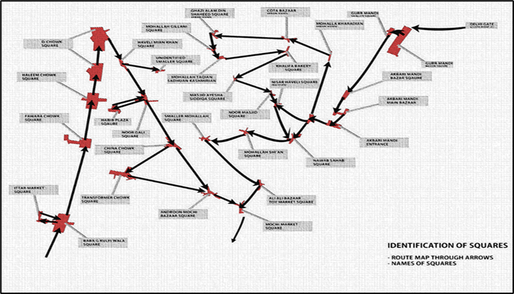
Similarly, Figure 6 shows the integration values of two zones of the Walled City with the most integrated being the red and the least integrated being the blue lines. It is interesting to see that the most well-connected roads are not necessarily the ones most integrated. Figure 5 shows the local integration value which is important to understand the integration at the neighborhood level. Global integration shows the relationship at the city level which has not been the scope of the current research exploration. After generating these maps, students labelled them with the street names and important locations to identify the urban squares that are most connected and integrated. These urban squares become the center of inquiry for this research and their socio-spatial character is further explored by putting them in connection with the derive through giga maps.
Figure 6
Integration Maps of Zone 3 and 4
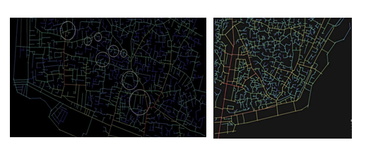
Figure 7
Process of Giga Mapping
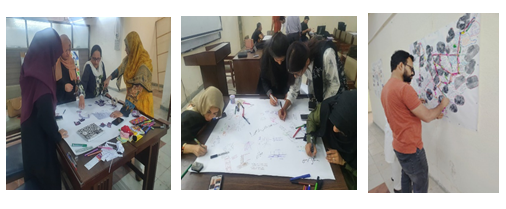
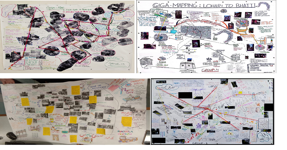
Once the derive and depth map analysis is completed, all the information collected is transformed into giga maps. For this, students had put data collected from these two methods on a big sheet of paper along with their observations and notes in the form of sketches and written notes. Students were asked to do this activity as a group and everyone was asked to put their personal observations on the paper as shown in the Figure 7. As a second step, they were asked to develop connections between these observations. These connections were made through the lines drawn on the paper at first and then through the threads by putting the giga maps on walls. Figure 6 shows students working on the giga maps, while Figure 8 shows the results of these maps and the connections generated in the collected data.
Figure 8
Results of the Giga Maps
Discussion
In this study, psychogeography and derive proved to be very useful tools and approaches to explore and understand the distinct character of the intangible aspects of the Walled City of Lahore. They enabled students to understand the historical layers of the city, peeking through its built environment and the lived experiences of the residents through the socio-cultural aspects. They could explore the intricate play between the city and its residents that was the objective of the research question set by the students. Through the derive, they explored the social life of residents in the prominent urban squares in the areas assigned to them. They gained a comprehensive understanding of the complex urban geography that unfolded for them as they wandered through the streets.
The students observed the daily routine of the inhabitants along with the social culture and practices of the Old City. They also got to understand about the vibrant commercial activities and how urban squares are acting as nodal points for this analysis as most of the activities are concentrated at these squares. Besides this, the students were also able to gather other sensory data, such as textures and materials of construction that helped them to experience the decaying status of most of the built structures. The soundscape helped them to gain insight on different activities, including people"s chit chat, traffic sounds and their relation to pedestrians, the voice of Adhan and people responding to it. The scents of all kinds allowed them to experience the culture through street food and at the same time let them see the lack of proper infrastructure through open manholes and exposed sewerage system. Due to the ability of derive to allow the connection of mind with space, students were able to make these observations and comprehend the unique intangible character of the Walled City of Lahore.
Figure 9
Urban Squares Maps of Zone 2
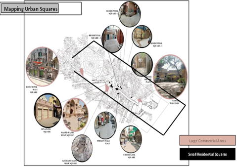
With the help of space syntax, students explored the physical infrastructure of the Walled City. They identified how the streets, roads, and squares are laid out physically and which areas are the most well-connected and integrated. However, the space syntax and depth map do not define the impact of this physical connection on the social and cultural life but psychogeography does explain this. By over-overlapping the ideas of space syntax and psychogeography through systems thinking, students were able to develop urban squares maps. Figures 9 and 10 are examples of these maps. Figure 11 is an example of the detailed analysis of the squares, particularly of Chowk Jhanda. Below is the quote from students' analysis of this square.
"Chowk Jhanda" is a very busy urban square with high social and retail activity as depicted from the derive that these activities and the shops are taking over the landscape of the square. There are many roads opening into the chowk and paving the way for this rich social life. The central part of the chowk is used for the parking of loader rikshaws for the caterers, while on one side of the filter plant people park their bikes. Moreover, two big transformers are also placed in the center of the chowk. When we did the analysis on the depth map, it showed the integration of Chowk Jhanda in a dark orange color which means high integration on scale and was verified during the derive.
Figure 10
Urban Squares Map of Zone 4
This research elucidates that the tools identified and discussed here provides a defined framework for understanding the socio-spatial structure of an urban area. Moreover, from the quotes of analysis done by the students, it is clear that using multiple methods of analysis has helped students triangulate their findings. They could confirm the findings of one method through the other methods, for example in the quote shared above the students could see that the integration value of Chowk Jhanda was high on the depth map and during derive they could not only confirm this but also experience the reasons of this high integration. Hillier and Hanson (1989), claimed that space syntax is the social logic of space but this social logic is not inherent in the way depth map works nor it is obvious from the results produced through the analysis, it does however, gives a spatial understanding of space, that is very tangible. As explained in the literature review, both derive and psychogeography helped to create a critical understanding of the site and its intangible aspects. A combination of these two methods brought together through the systems thinking is a framework that can be used for the analysis of any complex urban situation.
Conclusion
The findings showed that the tools used to carry out the research were very effective in understanding the tangible and intangible aspects of the Walled City as explained in the discussion session. It helped students to view the built environment from a new perspective which goes beyond the conventional techniques. Specific outcomes of the study showed that the urban squares of the Walled City are the hub of social and cultural life and the more connected an urban square is with the outside world, the more social activities it supports. This study faced certain limitations, one of which was the limitation of time as students had to understand the tools and create meaningful results within one semester. Another limitation was for students to conduct derive without preconceived notions for which they needed certain guidance, but even with it some students did struggle with it. An inquiry like this not only helps to understand how complexly urban environments work, but also furthers the grasp of tools and methods being used. For this reason, the execution of such experimental design studios and a report on their findings is necessary to take the knowledge forward.
Conflict of Interest
The author of the manuscript has no financial or non-financial conflict of interest in the subject matter or materials discussed in this manuscript.
Data Availability Statement
The data associated with this study will be provided by the corresponding author upon request.
Funding details
This research did not receive grant from any funding source or agency.
Bibliography
- Bassett, K. (2004). Walking as an aesthetic practice and a critical tool: Some psychogeographic experiments. Journal of Geography in Higher Education, 28(3), 397–410. https://doi.org/10.1080/0309826042000286965
- Bridger, A. J. (2013). Psychogeography and feminist methodology. Feminism & Psychology, 23(3), 285–298. https://doi.org/10.1177/0959353513481783
- Brown, M., & Brown, M. (2024). Psychogeography of the six towns: Lyric cartographies of stoke on Trent. In P. Holloway, & C. Jordan-Baker (Eds.), Writing landscape and setting in the Anthropocene: Britain and beyond. Springer International Publishing.
- Careri, F. (2017). Walkscapes: Walking as an aesthetic practice. Culicidae Architectural Press.
- Davidova, M. (2018, February 22–23). Roles, agency and relations of giga-maps in systemic approach to architectural performance: The special prototypes of post-anthropocene [Paper presentation]. Architecture, Media, Politics, Society (AMPS) Conference. Arizona, USA.
- Debord, G. (1987). The Society of the spectacle. Rebel Press.
- Debord, G., & Wolman, G. J. (1956). A user"s guide to detournement. Les Lèvres Nues, 8(7), 1–6.
- Ellard, C. (2018). The psychogeography of urban form: Building and measuring baukultur. Intertwining Magazine: Unfolding Art and Science. https://www.torrossa.com/en/resources/an/5149016
- Griffiths, S. (2017). Space syntax as interdisciplinary urban design pedagogy. In M. Carmona (Ed.), Explorations in urban design. Routledge.
- Gulzar, S. (2017). Traditional dwellings: An architectural anthropological study from the walled city of Lahore. Journal of Advances in Agricultural & Environmental Engineering, 4(1), 152–158.
- Haroon, F., Nawaz, M. S., Khilat, F., & Arshad, H. S. H. (2019). Urban heritage of the walled city of Lahore. Journal of Architectural and Planning Research, 36(4), 289–302.
- Hensel, M. U., & Sørensen, S. S. (2019). Performance-oriented architecture and urban design: Relating information-based design and systems-thinking in architecture. Formakademisk, 12(2), 1–17. https://doi.org/10.7577/formakademisk.2963
- Hillier, B. (2007). Space is the machine: A configurational theory of architecture. Space Syntax.
- Hillier, B., & Hanson, J. (1989). The social logic of space. Cambridge University Press.
- İlkay, Y. (2023). Psychogeography in planning: A new methodological approach via representations of "body", "urban space" and "walking". ICONARP International Journal of Architecture and Planning, 11(2), 584–603. https://doi.org/10.15320/ICONARP.2023.255
- Kelly, F. (2020). "Hurry up please, it's time!" A psychogeography of a decommissioned university campus. Teaching in Higher Education, 25(6), 722–735. https://doi.org/10.1080/13562517.2020.1746263
- Kim, M. (2021). The pedagogical effects of psychogeographic urban exploration and mapping. Geography, 106(2), 92–100. https://doi.org/10.1080/00167487.2021.1919412
- Lerman, Y., Rofè, Y., & Omer, I. (2014). Using space syntax to model pedestrian movement in urban transportation planning. Geographical Analysis, 46(4), 392–410. https://doi.org/10.1111/gean.12063
- McCahill, C., & Garrick, N. W. (2008). The applicability of space syntax to bicycle facility planning. Transportation Research Record, 2074(1), 46–51. https://doi.org/10.3141/2074-06
- McCandlish, A., & McPherson, G. (2021). Promoting tangible and intangible hidden cultural heritage: Local communities influencing civic decision-making and international cultural policy. International Journal of Cultural Policy, 27(5), 683–698. https://doi.org/10.1080/10286632.2020.1822348
- Monokrousou, K., & Giannopoulou, M. (2016). Interpreting and predicting pedestrian movement in public space through space syntax analysis. Procedia-Social and Behavioral Sciences, 223, 509–514. https://doi.org/10.1016/j.sbspro.2016.05.312
- Rana, I. A., & Bhatti, S. S. (2018). Lahore, Pakistan–urbanization challenges and opportunities. Cities, 72, 348–355. https://doi.org/10.1016/j.cities.2017.09.014
- Refaat, A. M. (2019). Space syntax theory and its contribution to urban design. In H. Abusaada, C. Vellguth & A. Elshater. (Eds.), Handbook of research on digital research methods and architectural tools in urban planning and design. IGI Global.
- Ryan, A. (2014). A framework for systemic design. Formakademisk, 7(4), 1–14. https://doi.org/10.7577/formakademisk.787
- Sadler, S. (2017). The Naked city: Guy Debord and Asger Jorn. In Companion to the history of architecture (pp. 1–12). John Wiley & Sons, Inc.
- Sevaldson, B. (2011, May 29–31). GIGA-Mapping: Visualization for complexity and systems thinking in design [Paper presentation]. Nordic Design Research Conference. Helsinki, Finland.
- Sevaldson, B. (2013, May 14–17). Systems Oriented Design: The emergence and development of a designerly approach to address complexity [Paper presentation]. 2nd International Conference for Design Education Researchers. Oslo, Norway.
- Sevaldson, B. (2017). Redesigning systems thinking. Formakademisk, 10(1), 1–23 https://doi.org/10.7577/formakademisk.1755
- Smith, P. (2010). The contemporary derive: a partial review of issues concerning the contemporary practice of psychogeography. Cultural Geographies, 17(1), 103–122. https://doi.org/10.1177/1474474009350002
- Wollen, P. (2001). Situationists and architecture. New Left Review, 8, 123–139
- Yunitsyna, A., & Shtepani, E. (2023). Investigating the socio-spatial relations of the built environment using the space syntax analysis–a case study of Tirana City. Cities, 133, Article e104147. https://doi.org/10.1016/j.cities.2022.104147
- Zahid, A., & Misirlisoy, D. (2021). Measuring place attachment, identity, and memory in urban spaces: Case of the walled city of Lahore, Pakistan. Journal of Architecture and Urbanism, 45(2), 171–182. https://doi.org/10.3846/jau.2021.15183