Analyzing Walkability in Hyderabad: A Study of Sakhi Sultan Road
Hina Kamal*, Shazia Abro, and Shah Rukh Noman
Department of Architecture & Planning, Shaheed Allah Buksh Soomro University of Art, Design and Heritages, Jamshoro, Pakistan
Abstract
The current study aimed to address the critical issue of climate change and the role of urbanization in exacerbating global warming. Urban sprawl and reliance on automobiles have led to the occurrence of significant urban problems. Therefore, the current study focused on the concept of walkability and its potential to foster sustainable urban neighborhoods. Walkability can be referred to as an effective green transport option that reduces congestion, environmental impact, and energy consumption while promoting healthier lifestyles and social cohesion. Moreover, the study also emphasized the necessity of innovative and strategic design and planning of neighborhood streets to enhance walkability. The research methodology comprised a case study of Sakhi Sultan Road in Hyderabad using field observations and visual analysis to assess the current condition and potential for improvement. The visual analysis identifies various environmental features that influence walkability including aesthetics, functionality, and safety. The findings revealed a mixture of present and absent features across different spots on the street. Additionally, the study also identified multiple issues, such as inadequate maintenance, lack of accessibility features, and encroachments on pedestrian pathways. All these issues highlight a need to improve and enhance walkability. Literature review supports the relationship between walkability and sustainability, citing that walkable environments enhance the quality of life, promote environmental sustainability, and reduce urban issues, such as traffic congestion and pollution. The study concluded with recommendations to address the highlighted issues and enhance the environmental features in order to foster a more walkable and sustainable urban environment.
Introduction
The importance of walkability in creating sustainable urban environments cannot be overstated. Designing and planning neighborhoods to be walkable is a strategic approach to address urban issues and promote sustainability. Walkable streets are characterized by features, such as wide sidewalks, pedestrian crossings, (Abdulla et al., 2017) street lighting, greenery, and mixed land use (Pandey, 2016). These elements make walking a safe, comfortable, and enjoyable mode of transport, encouraging more people to opt for walking over driving.
The current study focused on the role of walkability in creating sustainable neighborhoods, using Hyderabad's Sakhi Sultan Road as a case study. Hyderabad, like many rapidly growing cities, faces challenges related to urban sprawl and automobile dependence. By analyzing the current conditions of Sakhi Sultan Road, the current study aimed to identify the factors that influence walkability and proposed improvements to enhance the pedestrian experience.
Literature Review
Walkability is increasingly recognized as a critical component of sustainable urban development (Singh, 2016). It refers to how conducive an environment is to walking, encompassing various factors, such as street design, safety, accessibility, and presence of amenities (Risova, 2020). Research indicates that enhancing walkability may significantly reduce reliance on automobiles, thereby decreasing congestion, pollution, and energy consumption while promoting healthier lifestyles and social interaction (Keyvanfar et al., 2018).
Role of Walkability in Sustainable Urban Development
Recent studies have highlighted the multifaceted benefits of walkability in urban settings. For instance, a review by Baobeid et al. (2021) discussed how walkable environments contribute to public health, economic vitality, and environmental sustainability. The authors argued that walkability serves as a bridge linking health, livability, and sustainability, making it a vital consideration in urban planning.
Moreover, a study conducted by Zhang et al. (2019) emphasized that walkability is not only about physical infrastructure, however, also about creating a sense of place that encourages social interaction. The research suggested that urban areas designed with walkability foster community engagement and improve residents' quality of life.
Methodologies to Assess Walkability
The assessment of walkability has evolved, incorporating both qualitative and quantitative methodologies. For instance, a recent study introduced a walkability index that integrates pollutant exposure levels into the evaluation framework, providing a more comprehensive understanding of how environmental factors impact pedestrian health (Chen et al., 2023). This approach enables the urban planners to identify critical areas for improvement and prioritize interventions that enhance walkability.
Additionally, participatory assessment methods have gained traction, allowing communities to actively engage in evaluating their environments. This participatory approach not only empowers the residents, however, also yields valuable insights into the specific needs and preferences of different demographic groups (Cysek-Pawlak & Pabich, 2021).
Challenges in Enhancing Walkability
Despite the recognized benefits of walkability, several challenges persist. The literature has identified issues, such as inadequate maintenance of pedestrian infrastructure, lack of accessibility features, and urban encroachments that hinder walkability (Kinyingi et al., 2020). Addressing these challenges requires strategic planning and investment in pedestrian-friendly designs that prioritize safety and accessibility.
The case study of Sakhi Sultan Road in Hyderabad reflects these challenges (Kamal et al., 2022). Observations reveal a mixture of favorable and unfavorable conditions for walkability, underscoring the need for targeted interventions to enhance the street's pedestrian environment.
This literature review provides a foundation to understand the critical relationship between walkability and sustainable urban development, informing future research and policy-making in urban planning. Environmental features related to walkability of streets can be divided into three categories; aesthetics, function and safety (Soltani et al., 2018). Some environmental features related to walkability have been extracted from literature review and mentioned in Table 1 to set a parameter for analyzing the study area.
Table 1
Environmental Features related to Walkability
|
Aesthetics |
Function |
Safety |
|
Diverse building forms and outdoor dining area (Ewing & Handy, 2009). |
Constructed pathways, ramps, and crosswalks (Pikora et al., 2003). |
CCTV cameras, street lighting and phone booths (Bahrainy et al., 2015). |
|
Walls or trees lined on edges of street and sky ahead (Ewing & Handy, 2009). |
Mixed land use; diversity in building types (Pikora et al., 2003). |
Speed breakers, roundabouts, traffic lights, and traffic signs (Bahrainy et al., 2015). |
|
Landmarks, landscape features and architectural style (Ewing & Handy, 2009). |
Good street condition, and suitable width (Pikora et al., 2003). |
|
|
Adequate scale and proportion of buildings related to human scale (Ewing & Handy, 2009). |
||
|
Transparent glass walls, and large canopies of trees (Ewing & Handy, 2009). |
Research Methodology
Sequential Research Design was used in this study.
Case Study Selection
Location: Sakhi Sultan Road, Hyderabad.
Rationale: This area was selected due to its urban characteristics and the presence of various environmental features that can influence walkability.
Data Collection
Field Observations
Systematic observations were conducted to assess the physical conditions of the street including the presence of sidewalks, crossings, and pedestrian amenities. Aesthetic qualities were documented along with maintaining the levels of environment.
Visual Analysis
Photography and mapping techniques were used to visualize the spatial arrangement of walkability features (Shrestha, 2020). The collected visualized data was analyzed to identify the patterns and areas that need improvement.
Data Analysis
Qualitative analysis techniques were utilized to interpret field observation notes and visual analysis. Quantitative methods were employed to analyze survey data, identify correlations between perceived walkability and factors, such as safety, accessibility, and environmental quality.
Interpretations
Findings were presented from the analysis, highlighting the key environmental features that contribute to or detract from walkability. The implications of these findings were discussed for walkability and urban sustainability.
Derivations
Research findings and their significance were summarized in the context of urban sustainability and walkability. The potential for improved walkability was highlighted to contribute to more sustainable urban neighborhoods.
Study Area
Hyderabad city was selected as a study area for the current study due to its diverse urban fabric and rising automobile dependency which suggests a need for walkable streets and neighborhoods. In response to this, the present condition of streets should be studied to identify the plans required to enhance the walkability of streets.
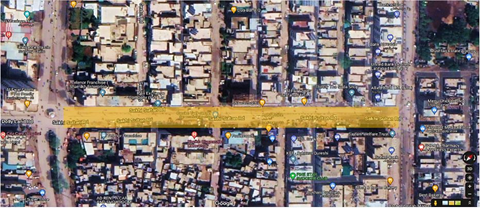
For this purpose, a street in Hyderabad named 'Sakhi Sultan Road' (shown in Figure 1) was selected to analyze its present condition and explore its capability to turn into a walkable street.
Figure 1
Satellite Imagery of the Selected Street (Highlighted with Yellow Color)
Note. Source: (Google map)
Street Attributes
The street is in Latifabad unit#7, Hyderabad, Sindh. It extends from south-west to north-east direction. It is 50 feet wide from the south-west corner and 40 feet wide from the north-east corner (Google map). On the south-west corner, there are two shops on each edge of the street namely, Zeeshan optics and White meat Chicken Shop. On the north-east corner, there are two shops on each edge of the street namely, Sindh Pan House and Saylani Welfare Trust (Ghori Dream City). The total length of the street selected for this study was 271 meters or 890 feet. Within this length, four spots were selected for in-depth understanding of walkability on this street.
Literature Mapping
Literature mapping was used in this research as a potent method to fulfill the following purposes:
- To acquire theoretical knowledge about walkability and related concepts by exploring numerous thesis dissertations, research papers, articles, and web sources.
- To identify the environmental features associated with walkability.
- To select methods and techniques for observing these features on the selected street. The method of visual analysis selected for this study is discussed below.
Visual Analysis
Visual analysis was conducted through serial vision method to establish a detailed picture about the existing walkability status of the selected street.
Serial Vision Method
- Four observation spots were marked on the map of the selected street.
- The street was physically visited and photographs were captured on each of the four observation spots of the street.
- The environmental features were pointed out in the photographs of the street to highlight these features (effective elements) present in the urban environment.
- Additionally, the missing features were highlighted to boost walkability in the area and better experience of pedestrians during walking.
Results
The results obtained by serial vision method of visual analysis on the selected street are mentioned below. Four spots on the street were selected and marked on the map. Afterwards, each spot was discussed in detail to understand the urban environment on each spot.
Serial Vision Method
The four spots selected on the street are mentioned in Figure 2. Spot 2 was selected as the primary spot on the street.
Figure 2
Satellite Imagery of the Selected Street (Green Circles for Selected Spots)
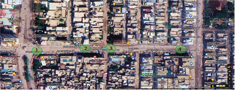
Note. Source: (Google map)
Spot 1
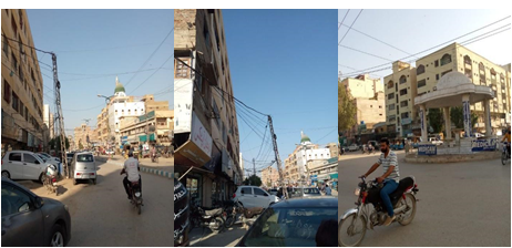
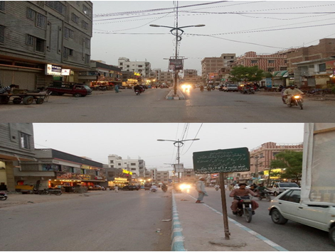
Figure 3(a) shows the south-west corner of the street. It also shows diversity in the form and proportion of buildings. A mosque is visible on the street from far away which acts as a landmark on the street. Buildings are lined on both edges of the street and sky is widely visible above the street. The street is in good condition and wide enough for pedestrians and traffic. It can be seen in the photograph that the footpath on one end of the street is occupied with cars and motorbikes. The shops on this edge are commercial shops and most of them are optics shops. An electricity pole can also be seen in the photograph between the traffic lane and footpath. A raised median in the center of the street along with streetlights was also found that directs two-way traffic.
Figure 3(b) shows Zeeshan optics shop and other commercial shops and all of them have transparent glass facades. The footpath area is covered with motorbikes and cars.
Figure 3(c) shows a roundabout at the end of the street. The street’s surface is plain with no holes or bumps.
The three photographs that were captured on spot 1 are shown below in Figure 3. Each photograph is discussed in detail to mention the observed elements on spot 1.
Figure 3
(a) Spot 1 Showing South-west Corner of the Street; (b) Zeeshan Optics Shop on Spot 1; (c) Spot 1 Showing Roundabout on the Street’s End
Spot 2
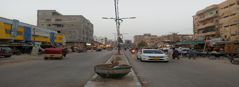
Figure 4 depicts the median in between the two lanes on the street. Streetlights and small planters are placed on the median. Diversity can be seen in types of buildings . On the right side of the photograph, there is a residential plaza and retail shops on the ground floor. On the left side of the photograph, there is a school on the first floor and hardware shops on the ground floor. Diversity can be observed in the color, material, and form of the building in the photograph. Smooth surface of the street and wide lanes are also visible in the photograph. Buildings are lined on both edges of the street and sky is wide open above the street. Some buildings show more height to width ratio than others. The footpath area is occupied with motorbikes and cars and shops have open facades, displaying their items.
The photograph shown in Figure 4 was captured on spot 2. This photograph is discussed in detail to mention the observed elements on spot 2.
Figure 4
Spot 2 of the Selected Street, showing its Median Separating the Two-way Traffic
Spot 3
Figure 5(a) and (b) show variety in the heights, materials, and colors of the buildings. Outdoor dining is also visible on this spot, where two restaurants including Al-Fajr Foods and Shawarma Chi provide a great outdoor sitting arrangement in front of their shops. On this spot, two other streets on the right and left side intersect with this street that can be seen in figure 5(a), where a break is provided in the median to turn around. Buildings are rowed on both edges of the street, with a few trees, and a broad view of sky is also visible above the street. Al-Fajr Foods acts as a landmark on this street which is known for its tasty food and people come here to enjoy it. Buildings or structures are not very tall and most buildings expand horizontally which relates to human scale. Facades of shops or restaurants are either open or have glass front. The street is in fine condition with a raised median in the center with streetlights. The street is sufficiently wide to accommodate traffic and pedestrians.
The two photographs shown in Figure 5 were captured on spot 3. Both photographs are discussed in detail to mention the observed elements on spot 3.
Figure 5
(a)Spot 3 of the Selected Street, showing Diverse Activities on the Street (b) a Closeup of Spot 3, showing its Various Features
Spot 4
The photograph shown in Figure 6 was captured on spot 4. This photograph is discussed in detail to mention the observed elements on spot 2.
Figure 6
(a)Spot 4 showing Street towards South-west Direction; (b) Spot 4 towards North-east Direction; (c) Spot 4 showing North-east Corner of the Street
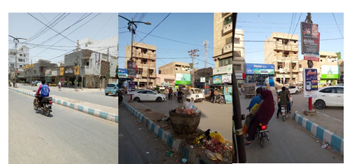
Figure 6(a) shows some horizontally stretched buildings that refer to human scale and an outdoor sitting for dining is also visible. Many small planters are placed on the median and in front of a restaurant. Buildings can be seen on one edge (west side of the street) and the sky is widely visible above the street. The median between the two lanes is wide enough to accommodate planters, streetlights, and sign boards that can be seen in the photograph. The street is clean, plain, and wide, having shops with open facades and parking on the footpath area.
Figure 6(b) shows the lack of maintenance on this spot, while a planter can be seen on the median with trash in the photograph. A residential plaza named Ghouri Dream City (right side of the photograph) on the north-east corner of the street can be seen. Raised median with streetlights and overhead sky is openly visible on this spot. The footpath area is occupied with kiosks, cars, and motorbikes.
Figure 6(c) shows the north-east end of the street and it has no roundabout on this spot. Traffic is moving in four directions and turning around without any circle or roundabout. The condition of the street is satisfactory.
The status of environmental features on spot 1 of the street is presented in Table 2. The present features on spot 1 of the street are marked with a tick, while the missing features on spot 1 are marked with a cross, along with the remarks, if any.
Table 2
Status of Environmental Features on Spot 1
|
Aesthetics |
Status |
Function |
Status |
Safety |
Status |
|
Diverse building forms and outdoor dining area. |
Outdoor dining was missing |
Constructed pathways, ramps, and crosswalks. |
Only pathways were present. |
CCTV cameras, street lighting, and phone booths. |
Only streetlighting was present. |
|
Walls or trees lined on the edges of street and sky ahead. |
Mixed land use; diversity in building types. |
Speed breakers, roundabouts, traffic lights, and traffic signs. |
Only roundabout was present. |
||
|
Landmarks and landscape features. |
Good street condition, and suitable width. |
||||
|
Adequate scale and proportion of buildings related to human scale. |
|||||
|
Transparent glass walls and large canopies of trees. |
Table 3
Status of Environmental Features on Spot 2
|
Aesthetics |
Status |
Function |
Status |
Safety |
Status |
|
Diverse building forms and outdoor dining area. |
Constructed pathways, ramps, and crosswalks. |
Only pathways were present. |
CCTV cameras, street lighting, and phone booths. |
Only streetlighting was present. |
|
|
Walls or trees lined on the edges of street and sky ahead. |
Mixed land use; diversity in building types. |
Speed breakers, roundabouts, traffic lights, and traffic signs. |
|
||
|
Landmarks and landscape features. |
Good street condition and suitable width. |
||||
|
Adequate scale and proportion of buildings related to human scale. |
|||||
|
Transparent glass walls and large canopies of trees. |
Large tree was missing. |
The summary of the status of environmental features on spot 2 of the street is given in Table 3. The present features on spot 2 of the street are marked with a tick, while the missing features on spot 2 are marked with a cross, along with the remarks, if any.
The summary of the status of environmental features on spot 3 of the street is given in Table 4. The present features on spot 3 of the street are marked with a tick, while the missing features on spot 3 are marked with a cross, along with the remarks, if any.
Table 4
Status of Environmental Features on Spot 3
|
Aesthetics |
Status |
Function |
Status |
Safety |
Status |
|
Diverse building forms and outdoor dining area. |
Constructed pathways, ramps, and crosswalks. |
Only pathways were present. |
CCTV cameras, street lighting, and phone booths. |
Only streetlighting was present. |
|
|
Walls or trees lined on the edges of street and sky ahead. |
Mixed land use; diversity in building types. |
Speed breakers, roundabouts, traffic lights, and traffic signs. |
|||
|
Landmarks and landscape features. |
Good street condition and suitable width. |
||||
|
Adequate scale and proportion of buildings related to human scale. |
|||||
|
Transparent glass walls and large canopies of trees. |
Table 5
Status of Environmental Features on Spot 4
|
Aesthetics |
Status |
Function |
Status |
Safety |
Status |
|
Diverse building forms and outdoor dining area. |
Constructed pathways, ramps, and crosswalks. |
Only pathways were present. |
CCTV cameras, street lighting and phone booths. |
Only streetlighting was present. |
|
|
Walls or trees lined on edges of street and sky ahead. |
Mixed land use; diversity in building types. |
Speed breakers, roundabouts, traffic lights, and traffic signs. |
|||
|
Landmarks, and landscape features. |
Good street condition, and suitable width. |
||||
|
Adequate scale and proportion of buildings related to human scale. |
|||||
|
Transparent glass walls, and large canopies of trees. |
The summary of the status of environmental features on spot 4 of the street is given in Table 5. The present features on spot 4 of the street are marked with a tick, while the missing features on spot 4 are marked with a cross, along with the remarks, if any.
Discussion
Through an analysis of the literature review, several associated factors with walkability were found. Out of them, a list of ten environmental features were picked and classified into three groups to conduct this study and to understand the condition of walkability on the selected street. The method selected to analyze these features was qualitative due to the informal nature of the concept of walkability and its measuring methods. Qualitative method facilitates complicated happenings to be explored in a deeper way. It also helps to determine multiple factors and their association with each other. The current research explored the concept of walkability along with its link to other physical features in the urban environment. The outcomes of the methods used in this research show that the street collectively on all spots has six present environmental features and three missing environmental features on it. The missing features included ramps for handicapped people, marked crosswalks for pedestrians to allow them easy access from one side of the street to another, CCTV cameras for the surveillance of street and controlling crime rate, phone booths for emergency use, traffic lights, and traffic signs for safety of pedestrians from traffic. There were some issues on the street, such as street parking which occupied the footpath area and lack of maintenance on a few spots. These issues should be addressed to overcome the hurdles in achieving greater walkability on this street. Additionally, the missing features listed in this discussion should be provided to enhance the pedestrian’s experience.
The street known as 'Sakhi Sultan Road' was studied as a case for the current research to understand the possibility of this street becoming walkable. The results mentioned in Table 2-Table 5 suggest that most of the environmental features (selected for this study) were present on this street, while a few were missing. It may be concluded that this street has the capacity to be turned into a walkable street. Moreover, this street is widely used by most of the residents of Latifabad unit#7 and surrounding areas. However, to increase the walkability score of the street and encourage pedestrians, a few improvements are needed on a neighborhood scale. Additionally, many other streets like these need to be highlighted to increase the number of walkable streets and hence make walkable cities.
Conflict of Interest
The author of the manuscript has no financial or non-financial conflict of interest in the subject matter or materials discussed in this manuscript.
Data Availability Statement
The data associated with this study will be provided by the corresponding author upon request.
Bibliography
Abdulla, K. M., Abdelmonem, M. G., & Selim, G. (2017). Walkability in historic urban spaces: Testing the safety and security in martyrs' square in Tripoli. International Journal of Architectural Research: ArchNet-IJAR, 11(3), 163–177. http://doi.org/10.26687/archnet-ijar.v11i3.1378
Bahrainy, H., Khosravi, H., Aliakbari, F., & Khosravi, F. (2015). The impact of built environment on walkability, case study: North-west of Shiraz. Armanshahr, 8(14), 105–117.
Baobeid, A., Koç, M., & Al-Ghamdi, S. G. (2021). Walkability and its relationships with health, sustainability, and livability: Elements of physical environment and evaluation frameworks.Frontiers in Built Environment,7, Article e721218. https://doi.org/10.3389/fbuil.2021.721218
Chen, Y., Zhang, J., & Li, X. (2023, July 14–17). Research on street walkability evaluation considering travel health [Paper presentation]. Proceedings of 23rd COTA International Conference of Transportation Professionals. Beijing, China
Cysek-Pawlak, M. M., & Pabich, M. (2021). Walkability–the New Urbanism principle for urban regeneration.Journal of Urbanism: International Research on Placemaking and Urban Sustainability,14(4), 409–433. https://doi.org/10.1080/17549175.2020.1834435
Ewing, R., & Handy, S. (2009). Measuring the unmeasurable: Urban design qualities related to walkability. Journal of Urban Design, 14(1), 65–84. https://doi.org/10.1080/13574800802451155
Kamal, H., Memon, I. A., Sahito, N., Abro, S., Marvi, H., & Soomro, M. (2022). Walkability and environmental features interdependence.International Journal of Early Childhood Special Education, 14(6), 876–886. https://doi.org/10.9756/INTJECSE/V14I6.99
Keyvanfar, A., Ferwati, M. S., Shafaghat, A., & Lamit, H. (2018). A path walkability assessment index model for evaluating and facilitating retail walking using decision-tree-making (DTM) method. Sustainability, 10(4), Article e1035. https://doi.org/10.3390/su10041035
Kinyingi, J., Mugwima, N., & Karanja, D. (2020). Walkable streets: A study of pedestrians’ perception, and attitude towards Ngei Street in Machakos Town. Current Urban Studies, 8(3), 381–395. http://doi.org/10.4236/cus.2020.83021
Pandey, A. D. (2016). Quantitative and qualitative analysis of walkability of Indian street: A case of luck now. Civil Engineering and Urban Planning: An International Journal, 3(3), 13–28.
Pikora, T., Giles-Corti, B., Bull, F., Jamrozik, K., & Donovan, R. (2003). Developing a framework for assessment of the environmental determinants of walking and cycling. Social Science & Medicine, 56(8), 1693–1703. https://doi.org/10.1016/S0277-9536(02)00163-6
Risova, K. (2020). Walkability research: Concept, methods and a critical review of post-socialist studies. Geografický ˇCasopis, 72, 219–242. https://doi.org/10.31577/geogrcas.2020.72.3.11
Shrestha, S. (2020). Walkability and built environment. Grin Verlag.
Singh, R. (2016). Factors affecting walkability of neighborhoods. Procedia-Social and Behavioral Sciences, 216, 643–654. https://doi.org/10.1016/j.sbspro.2015.12.048
Soltani, A., Hosseinpour, M. & Zare, P. (2018). The development and assessment of environmental features associated with walkability of urban streets. Theoretical and Empirical Researches in Urban Management, 13(1), 22–36.
Zhang, J., Tan, P. Y., Zeng, H., & Zhang, Y. (2019). Walkability assessment in a rapidly urbanizing city and its relationship with residential estate value. Sustainability, 11(8), Article e2205. https://doi.org/10.3390/su11082205