
Urban Flood Risk Mapping and Vulnerability Assessment in Gwadar: A GIS-based Approach
DOI:
https://doi.org/10.32350/jaabe.82.04Keywords:
urban flooding, flood risk assessment, GIS spatial analysis, socio-economic vulnerability, coastal urban resilienceAbstract
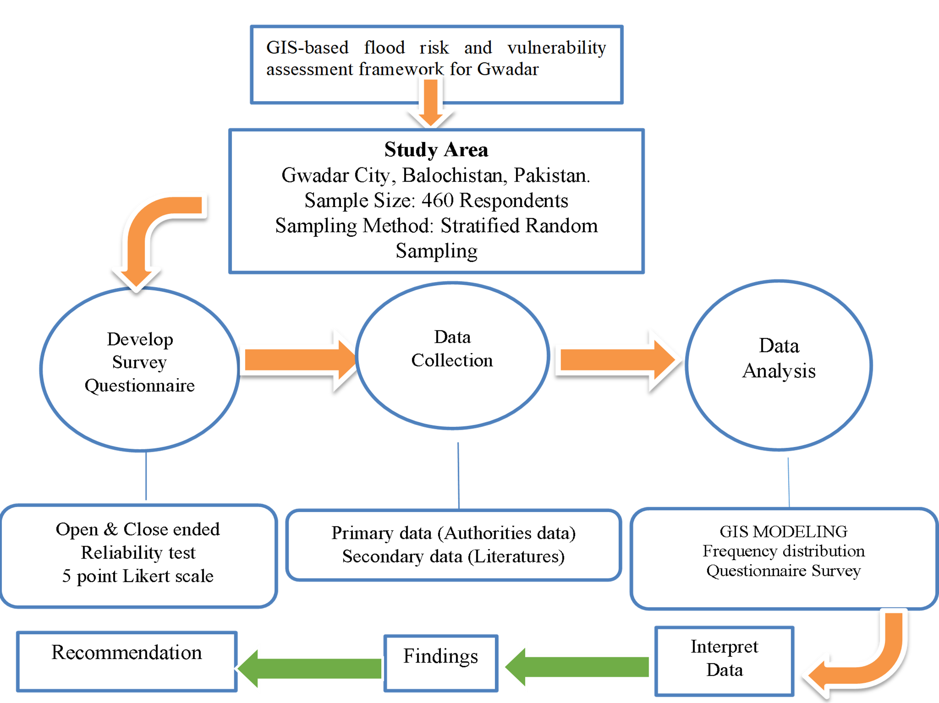
Urban flooding has become an increasingly severe global challenge, particularly affecting cities in developing nations where rapid and unregulated urbanization, deficient infrastructure, and climate change converge to create compounded risks. Gwadar, a strategic coastal city in Balochistan, Pakistan, exemplifies this vulnerability. Positioned at the heart of the China-Pakistan Economic Corridor (CPEC), the city is undergoing rapid transformation yet remains critically unprepared for recurring flood events. This research employs a mixed-methods design integrating Geographic Information Systems (GIS)-based spatial analysis with a survey-based socio-economic vulnerability assessment. High-resolution topographic data, land use classification, are combined with structured community surveys (N=286) to develop a comprehensive flood risk profile for Gwadar. A composite Urban Flood Risk Perception Index (UFRPI) is constructed using four dimensions: exposure, sensitivity, adaptive capacity, and mitigation trust, reflecting how residents perceive and experience flood vulnerability. GIS-based flood risk maps reveal severe exposure in low-lying coastal areas including Faqeer Colony, Nayabad, Main Bazaar, and Old Town. Meanwhile, socio-economic indicators such as income, housing quality, and education level show a strong correlation with perceived risk, particularly in informal settlements. The UFRPI scores confirm significant concern over institutional readiness and resilience capacity.
Downloads
References
Alshammari, E., Rahman, A. A., Rainis, R., Seri, N. A., & Fuzi, N. F. A. (2023). The impacts of land use changes on urban hydrology, runoff, and flooding: A review. Current Urban Studies, 11(1), 120–141. https://doi.org/10.4236/cus.2023.111007
Anand, V., Yousfani, K., & Zhang, J. (2020). Financial implications of natural disasters: A case study of floods in Pakistan. In International Case Studies in the Management of Disasters: Natural–Manmade Calamities and Pandemics. Emerald Publishing. https://doi.org/10.1108/978-1-83982-186-820201005
Atta-Ur-Rahman, & Shaw, R. (2015). Flood risk and reduction approaches in Pakistan. In Disaster Risk Reduction Approaches in Pakistan (pp. 77–100). Springer. https://doi.org/10.1007/978-4-431-55369-4_4
Barlaas, K. H., Ur Rehman, H., Siddique, M., Shakir, A. S., & Akhtar, M. N. (2017). Flood inundation mapping for Gwadar City. MATEC Web of Conferences, 120, Article e05012. https://doi.org/10.1051/matecconf/201712005012
Barua, S., & Van Ast, J. (2007). Towards interactive urban flood management: A case of Dhaka, Bangladesh (Master’s Thesis). Erasmus University Rotterdam. https://thesis.eur.nl/pub/12128
Budiyono, Y., Aerts, J., Brinkman, J. J., Marfai, M. A., & Ward, P. (2015). Flood risk assessment for delta mega-cities: A case study of Jakarta. Natural Hazards, 75(1), 389–413. https://doi.org/10.1007/S11069-014-1327-9
Chen, Y., Zhang, Y., Tao, D., Zhang, W., You, J., Li, Y., Lei, Y., & Meng, Y. (2025). Exploring socio-spatial inequalities in flood response using flood simulation and social media data: A case study of 2020 flood in Nanjing, China. Climate, 13(5), Article e92. https://doi.org/10.3390/CLI13050092
Dharmarathne, G., Waduge, A. O., Bogahawaththa, M., Rathnayake, U., & Meddage, D. P. P. (2024). Adapting cities to the surge: A comprehensive review of climate-induced urban flooding. Results in Engineering, 22, Article e102123. https://doi.org/10.1016/j.rineng.2024.102123
Duy, P. N., Chapman, L., Tight, M., Linh, P. N., & Thuong, L. V. (2018). Increasing vulnerability to floods in new development areas: Evidence from Ho Chi Minh City. International Journal of Climate Change Strategies and Management, 10(1), 197–212. https://doi.org/10.1108/IJCCSM-12-2016-0169
Gilandeh, A. G., Sobhani, B., & Ostadi, E. (2020). Combining ArcGIS and OWA model in flooding potential analysis. Natural Hazards, 102(3), 1435–1449. https://doi.org/10.1007/S11069-020-03975-0
Gupta, L., & Dixit, J. (2022). GIS-based flood risk mapping using MCDA-AHP approach in Assam, India. Geocarto International, 37(26), 11867–11899. https://doi.org/10.1080/10106049.2022.2060329
Gwadar Development Authority. (2019). Gwadar Master Plan 2019. Government of Balochistan, Pakistan.
Hallegatte, S., Vogt-Schilb, A., Bangalore, M., & Rozenberg, J. (2017). Unbreakable: Building the resilience of the poor in the face of natural disasters. World Bank. https://doi.org/10.1596/978-1-4648-1003-9
Ibrahim, M., Huo, A., Ullah, W., Ullah, S., Ahmad, A., & Zhong, F. (2024). Flood vulnerability assessment in flood-prone areas of Khyber Pakhtunkhwa, Pakistan. Frontiers in Environmental Science, 12, Article e1303976. https://doi.org/10.3389/FENVS.2024.1303976
Islam, A. R. M. T., Talukdar, S., Mahato, S., Kundu, S., Eibek, K. U., Pham, Q. B., & Linh, N. T. T. (2019). Flood susceptibility modelling using advanced ensemble machine learning models. Journal of Hydrology, 574, 877–894. https://doi.org/10.1016/j.jhydrol.2019.04.072
Khosravi, K., Shahabi, H., Pham, B. T., Adamowski, J., Shirzadi, A., & Pradhan, B. (2019). Comparative flood susceptibility modelling using MCDA and machine learning. Journal of Hydrology, 573, 311–323. https://doi.org/10.1016/J.JHYDROL.2019.03.073
Kundzewicz, Z. W., Pińskwar, I., & Brakenridge, G. R. (2023). Floods in the changing climate: Trends and challenges. Hydrological Sciences Journal, 68(1), 1–17. https://doi.org/10.1080/02626667.2022.2156759
Mohuya, F. A., Walsh, C. L., & Fowler, H. J. (2025). Urban flood risk management through citizen science: Dhaka case study. International Journal of Disaster Risk Reduction, 124, Article e105405. https://doi.org/10.1016/J.IJDRR.2025.105405
National Disaster Management Authority (NDMA). (2023). Situation report: Heavy rainfall and urban flooding in Balochistan (February 2023). Government of Pakistan.
Poussin, J. K., Botzen, W. J. W., & Aerts, J. C. J. H. (2014). Factors of influence on flood damage mitigation behaviour by households. Environmental Science & Policy, 40, 69–77. https://doi.org/10.1016/j.envsci.2014.01.013
Sebastian, A., Juan, A., & Bedient, P. B. (2022). Urban flood modeling: Perspectives, challenges, and opportunities. In Coastal Flood Risk Reduction (pp. 47–60). Elsevier. https://doi.org/10.1016/B978-0-323-85251-7.00005-6
Tomar, P., Singh, S. K., Kanga, S., Pattanaik, A., & Meraj, G. (2024). Use of geospatial techniques in urban flood hazard management. In Disaster Management and Environmental Sustainability (pp. 155–167). Wiley. https://doi.org/10.1002/9781394167463.ch13
Ullah, N., Tariq, A., Qasim, S., Panezai, S., Uddin, M. G., Abdullah-Al-Wadud, M., & Ullah, S. (2024). Geospatial analysis and AHP for flood risk mapping in Quetta, Pakistan. Applied Water Science, 14(11), 1–18. https://doi.org/10.1007/S13201-024-02293-1
Wang, M., Fu, X., Zhang, D., Chen, F., Liu, M., Zhou, S., Su, J., & Tan, S. K. (2023). Assessing urban flooding risk in response to climate change and urbanization. Science of the Total Environment, 880, Article e163470. https://doi.org/10.1016/j.scitotenv.2023.163470
Waseem, M., Ahmad, S., Ahmad, I., et al. (2023). Urban flood risk assessment using AHP and geospatial techniques in Swat, Pakistan. SN Applied Sciences, 5, 215. https://doi.org/10.1007/s42452-023-05445-1
Yamane, T. (1967). Statistics: An introductory analysis (2nd ed.). New York, NY: Harper & Row.
Downloads
Published
How to Cite
Issue
Section
License
JAABE follows an open-access publishing policy and full text of all published articles is available free, immediately upon publication of an issue. The journal’s contents are published and distributed under the terms of the Creative Commons Attribution 4.0 International (CC-BY 4.0) license. Thus, the work submitted to the journal implies that it is original, unpublished work of the authors (neither published previously nor accepted/under consideration for publication elsewhere). On acceptance of a manuscript for publication, a corresponding author on the behalf of all co-authors of the manuscript will sign and submit a completed Copyright and Author Consent Form.
Copyright (c) The Authors